Saguenay Fjord
Saguenay Fjord: the only inhabited fjord in North America. Granite walls rising 500 m, whales at the mouth, Cap Trinité, and kayaking through silence.
La Baie: 3-Hour Saguenay Fjord Classic Cruise
Duration: 3 hours
Quick facts
- Length
- ~100 km from Alma to the Saint-Laurent
- Depth
- Up to 275 m; walls rise 300–500 m above water
- Designation
- Parc national du Fjord-du-Saguenay (Sépaq)
- Key villages
- Sainte-Rose-du-Nord, L'Anse-Saint-Jean, Anse de Roche
- Ferry
- L'Anse-Saint-Jean ↔ Rivière-Éternité (seasonal, Sépaq)
- Currency
- CAD (taxes ~15%)
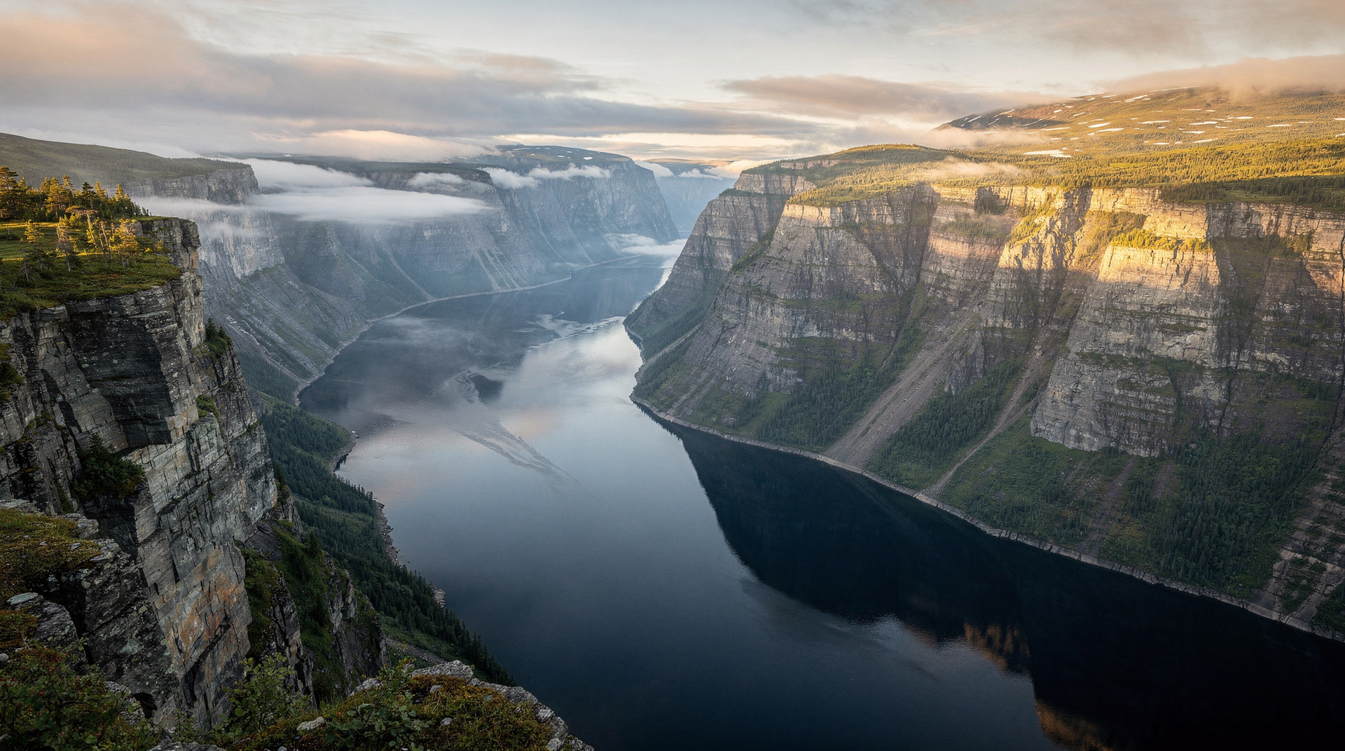
The only inhabited fjord in North America
The Saguenay Fjord is a geological anomaly: a river canyon carved by glacial action into the Precambrian Canadian Shield, running 100 km from the town of Alma (where the Lac-Saint-Jean outlet narrows into the Rivière Saguenay) to the Saint-Laurent at Tadoussac. What makes it a fjord — rather than simply a deep river valley — is that the ice sheet that carved it also compressed the rock below sea level; when the glaciers retreated 10,000 years ago, the Saint-Laurent extended its tidal reach far inland, filling the valley with salt water to a depth of 275 m. The result is a body of water with the physical character of a Scandinavian fjord — granite walls descending into dark, cold water, forested slopes broken by cliff faces — in the middle of Québec.
The fjord is not wilderness in the strict sense: it has been inhabited since the seventeenth century and small villages dot both shores. This cohabitation of dramatic landscape and quiet human settlement is precisely what makes it distinctive. Sainte-Rose-du-Nord and L’Anse-Saint-Jean, the two villages most visited, have populations of a few hundred people and services to match — a handful of B&Bs, simple restaurants, a few kayak outfitters — set against a backdrop that photographs as Scandinavia but is, in fact, entirely Québécois.
Boat cruise from La Baie (Saguenay)
The most efficient way to experience the fjord is by boat from La Baie, the southernmost urban district of Saguenay city, which puts in at the industrial quay and runs toward the Saint-Laurent through the heart of the fjord.
La Baie 3-hour Saguenay Fjord classic cruise (around 36 CAD) is the best-value boat experience in the region — three hours on the fjord with commentary on the geology, ecology, and history of the canyon, departing from the La Baie marina. The lower price reflects the departure point (La Baie rather than Tadoussac) and the fact that whale sightings are less frequent at this end of the fjord than at the mouth. But the fjord itself — the walls, the colour of the water, the forested ridges — is the experience, and this tour delivers it at a fraction of the Tadoussac price.
For whale sightings combined with fjord scenery, the tours departing from Tadoussac at the fjord mouth offer higher probability of cetacean encounters.
Whales and fjord morning or twilight tour from Tadoussac (around 85 CAD) enters the Saguenay mouth and combines fjord scenery with whale watching — effectively both experiences in one tour, though the fjord coverage is limited to the first 15–20 km from the mouth.
Cap Trinité and the Notre-Dame de Saguenay statue
Cap Trinité is the fjord’s most recognizable landmark: a 350 m cliff face with a large white statue of Notre-Dame de Saguenay perched at the second ledge, 181 m above the water. The statue was placed there by a local merchant in 1881 after he survived a winter on the ice — a story that says something about the spiritual dimensions of the landscape in nineteenth-century Québec.
The approach by boat reveals the scale gradually — the statue appears small from a distance and grows as you approach the cliff. From the water, it is an improbable and genuinely moving sight. The hiking trail to the base of the statue departs from Rivière-Éternité on the south shore of the fjord (accessible by car from Jonquière or by the seasonal ferry from L’Anse-Saint-Jean). The round trip takes 3–4 hours through hardwood forest before emerging at the cliff edge above the statue.
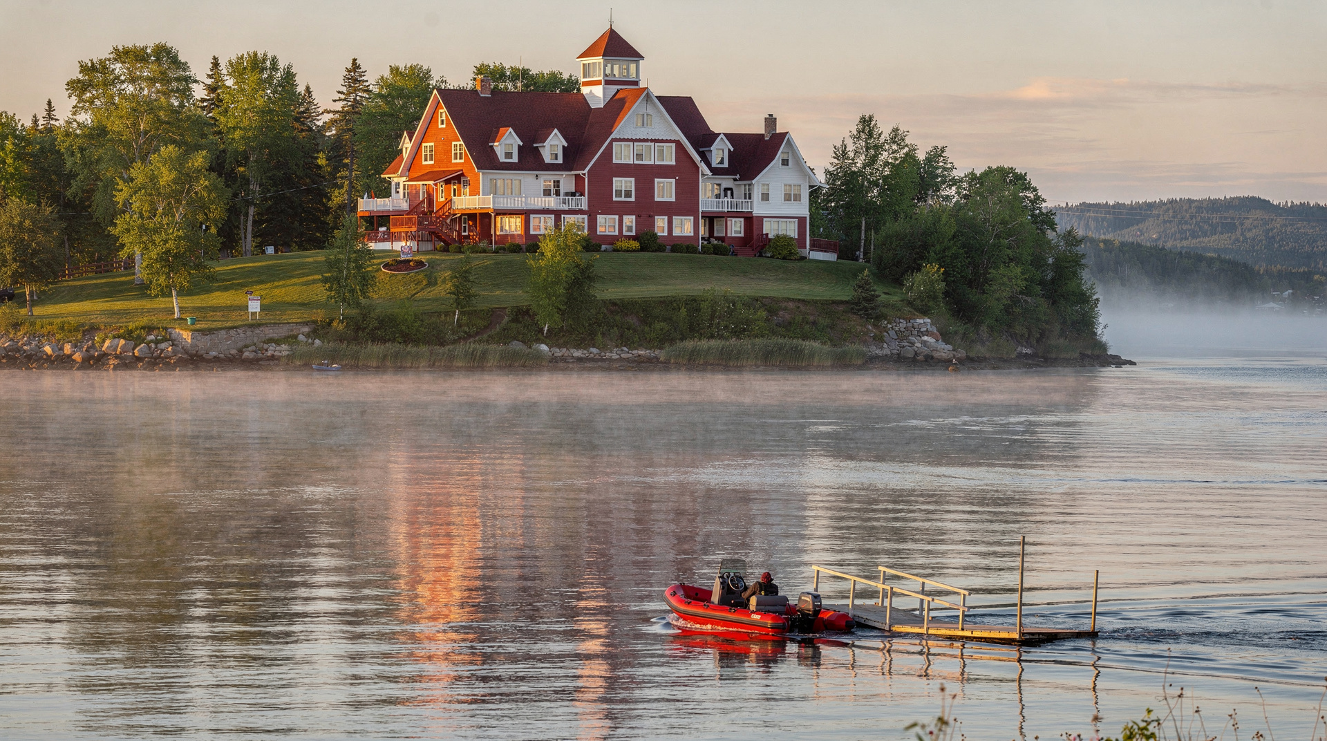
Sainte-Rose-du-Nord
Sainte-Rose-du-Nord, on the north shore of the fjord accessible by Route 172 from Chicoutimi, is the most photographed village in the Saguenay. It sits at the base of a narrow valley that opens into the fjord, with a small harbour, colourful houses on the hillside, and a trail system that climbs through the forest above the village to viewpoints over the fjord.
The Musée de la nature in the village is tiny but excellent — a natural history collection assembled by a local ornithologist over decades, with specimens and displays of the birds and mammals of the fjord ecosystem. The auberge in the village is among the best value accommodation on the fjord.
L’Anse-Saint-Jean: kayak base
L’Anse-Saint-Jean, on the south shore, is the main kayaking centre of the fjord. The village has a covered bridge (one of the last in Québec) and access to both the fjord and the Rivière Saint-Jean that enters it here. Several kayak outfitters offer day and multi-day rentals and guided paddles into the fjord.
Kayaking the fjord is not a beginner activity in the open water sections — the thermal and tidal dynamics create conditions that require proper paddling technique and appropriate gear. The sheltered sections near L’Anse-Saint-Jean are more forgiving. Guided day tours from local outfitters brief participants on conditions and appropriate routes.
Parc national du Fjord-du-Saguenay
The park covers both shores of the fjord and is managed by Sépaq. Trail networks accessible from multiple parking areas along Routes 170 (south shore) and 172 (north shore) offer hiking at all levels. The Sentier des Caps on the north shore and the Cap Trinité trail on the south shore are the signature routes. Camping within the park (Sépaq reservations) allows for multi-day fjord immersion.
The park charges a daily entry fee (around 9 CAD per adult) payable at the welcome stations. Download the Sépaq app for current trail conditions and booking.
Snowmobiling the fjord rim
The fjord in winter — ice on the coves, snow on the forest ridges, cold clear air — is a different and equally compelling experience. The snowmobile trail network follows the fjord rim on both shores, and there are ice-road sections on the frozen coves that allow snowmobilers to cross the fjord at certain points. This is the local way to experience the fjord in winter; guided tours depart from Saguenay city.
Wildlife on the fjord
The combination of freshwater inputs, deep cold water, and tidal mixing creates a productive marine environment even far inland from the Saint-Laurent. The beluga whales that use the Saguenay as a calving ground occasionally appear well up the fjord — particularly near the confluence at Tadoussac — and harbour seals haul out on rocks throughout the lower fjord. Bald eagles nest along the upper fjord cliffs and are visible year-round. The forest on both shores holds moose, black bear, and white-tailed deer; moose sightings at dusk on the fjord shore are not unusual.
The Saguenay–Saint-Laurent Marine Park manages the fjord as a protected area in conjunction with the terrestrial Parc national du Fjord-du-Saguenay (Sépaq). Commercial whale-watching boats entering the fjord from Tadoussac operate under park regulations for minimum exclusion distances.
Multi-day fjord itinerary
A genuine fjord experience requires at least two days — one is enough to see the landscape from the boat, but two gives you a morning at Sainte-Rose-du-Nord, an afternoon kayak at L’Anse-Saint-Jean, and time to walk the trails to the viewpoints above the fjord that reveal its full scale.
Suggested two-day route:
Day 1: Arrive La Baie, take the afternoon fjord cruise, evening in Saguenay city. Night at La Baie or Saguenay.
Day 2: Drive Route 172 north shore to Sainte-Rose-du-Nord (1h from Chicoutimi). Walk the trail above the village for fjord views. Continue west on Route 172 to the park boundary. Return south and cross to the south shore via ferry at L’Anse-Saint-Jean (check seasonal schedule). Walk to the covered bridge and arrange an evening kayak paddle from L’Anse-Saint-Jean. Drive back toward Québec City on Route 170 (Jonquière, then Route 175 south).
This circuit covers both shores, gives time for walking and water, and does not repeat any road.
Anse de Roche: the hidden cove
Anse de Roche, 20 km east of Sacré-Cœur on Route 172, is a small cove where the fjord narrows to its most dramatic proportions. The walls at this point rise nearly vertically and the water depth reaches 275 m — the deepest section of the fjord. There is a small picnic area at the waterside and a short trail that climbs the south wall for an aerial perspective. Few day-trippers make it this far from Tadoussac.
Photography on the fjord
The fjord rewards photographers at dawn and in late afternoon when the low-angle light catches the cliff faces and the water surface reflects the forest ridges above. The optimal position for dawn shots of Cap Trinité is from the boat — the approach from the east as the sun rises behind the cliff illuminates the face directly. The Sentier des Caps on the north shore provides elevated positions over the fjord for wide-angle compositions.
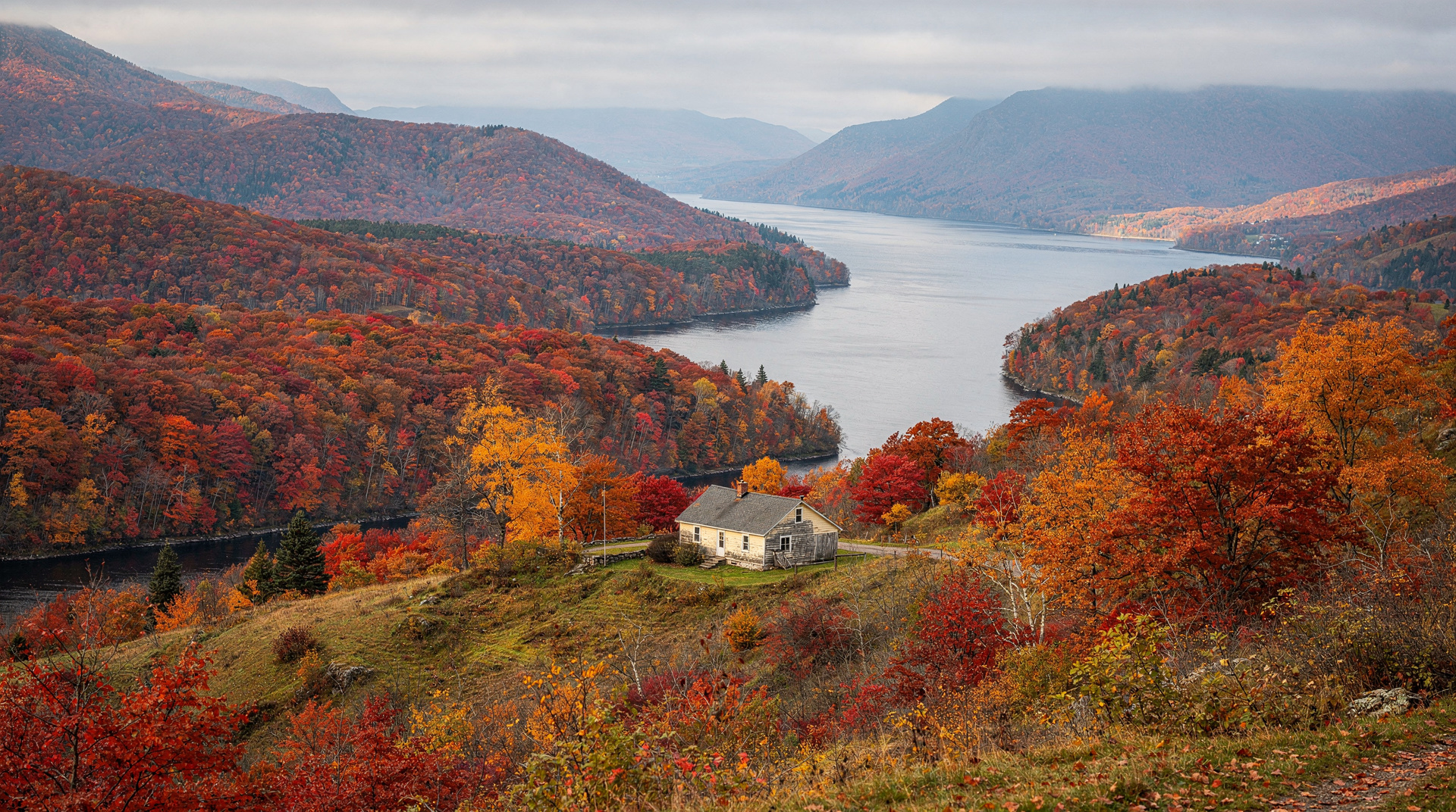
Autumn is the best season for colour photography: the forest on the fjord walls turns in the first two weeks of October, and the contrast of red and yellow against dark water and grey granite is technically excellent. The boat cruise in peak foliage week delivers images that summer visits cannot.
Planning a fjord visit with limited time
If you have only one day for the fjord arriving from Québec City or Tadoussac:
-
Coming from Tadoussac: Take the morning whale/fjord tour that enters the Saguenay mouth (covers the best fjord scenery without driving). If time allows, drive Route 172 to Sainte-Rose-du-Nord (1h from Tadoussac via the north shore bridge at Sacré-Cœur) for the village views.
-
Coming from Saguenay: Take the La Baie 3-hour cruise in the afternoon. Drive Route 172 north shore in the morning to Sainte-Rose-du-Nord before the cruise departure.
-
Driving through on a Québec circuit: Route 170 (south shore) between Saguenay and Tadoussac via L’Anse-Saint-Jean gives fjord views through the windshield and roadside stops at the park access points. The complete drive takes about 2h without stops.
Practical notes
- Routes: South shore access via Route 170 from Saguenay (La Baie); north shore via Route 172 from Chicoutimi (Sainte-Rose-du-Nord at the fjord end)
- Ferry: L’Anse-Saint-Jean to Rivière-Éternité operates seasonally (confirm with Sépaq)
- Driving time: Tadoussac to L’Anse-Saint-Jean by road takes about 1h30 (the fjord is not directly crossable without the ferry)
- Camping: Sépaq parks in the system require advance reservation for July–August
- Cell service: Limited within the park; plan navigation offline
- Connections: Saguenay city for urban services; Tadoussac for whale watching at the fjord mouth
Why the Saguenay Fjord is geologically unique
For the scientifically curious visitor: the Saguenay is unique in North America for being both a fjord in the strict geological sense and an inhabited river. The distinction between a fjord and a canyon is a matter of glacial history and sea level: the Saguenay valley was carved by glacial ice and subsequently flooded by saltwater as post-glacial sea levels rose, creating an arm of the ocean rather than a freshwater river despite its inland position. The boundary between salt and freshwater — the halocline — occurs at depth in the fjord; the river inflow from the Lac-Saint-Jean drainage above creates a thin freshwater cap over the heavier saltwater below.
This stratification creates the dark, anoxic conditions in the fjord’s deepest sections (below 200 m) that preserve organic material in extraordinary detail. Archaeological investigations of the fjord bottom have recovered 17th-century artefacts from the earliest European trading posts at Chicoutimi in excellent condition.
The only inhabited fjords in North America outside Alaska are the Saguenay and a handful of smaller inlets in Newfoundland — none of comparable size or accessibility.
Local communities along the fjord
Beyond the main visit points, several smaller communities along the fjord are worth mentioning for visitors who want to go off the main tourist circuit.
Anse de Roche (north shore, Route 172): A small cove with a picnic area and a trail climbing the north wall. The narrowest and deepest section of the fjord is visible from here. Very few visitors.
Rivière-Éternité (south shore, Route 170): The village at the base of Cap Trinité with the Sépaq park reception and the ferry terminal to L’Anse-Saint-Jean. The village church dates to 1907 and contains a memorial to mariners lost on the fjord — a reminder that the waterway, beautiful as it is, has a history of maritime incidents.
Petit-Saguenay (south shore, Route 170): A farming village on a small river valley entering the fjord. The valley farmland here contrasts with the vertical fjord walls — an unusual juxtaposition.
Seasonal overview
| Season | Character | Main activity |
|---|---|---|
| May–June | Green-up, cold water, few visitors | Birding, early hikes |
| July–August | Peak tourism, warmest water | Boat cruise, kayak, swimming in coves |
| September | Excellent weather, fewer crowds | Hiking, photography, mushroom foraging |
| October | Peak foliage (first two weeks) | Foliage drive, late season hikes |
| November–March | Snow on the cliffs, ice in coves | Snowmobile, snowshoe, ice fishing (coves) |
The fjord is accessible and worth visiting in all seasons, but the boat tour season (June through mid-October) defines the main tourist window. Outside this period, the fjord is accessed primarily by snowmobile and winter hiking.
Top experiences
Bookable activities with verified prices and instant confirmation on GetYourGuide.