Saint-Jean-sur-Richelieu
Home to the world's largest balloon festival each August, a historic fort on the Richelieu River, and the gateway to Lake Champlain and the US border.
Updated:
Quick facts
- Distance from Montreal
- 45 km south, ~45 min by car
- Balloon festival
- International de montgolfières, 2nd week of August (10 days)
- River
- Richelieu River (connects St. Lawrence to Lake Champlain / US border)
- Via Rail
- Train from Montréal Central (approx. 1h, Mon-Fri commuter service)
A note on GetYourGuide coverage
Saint-Jean-sur-Richelieu does not currently have GetYourGuide-listed tours or activities. This page is editorial — it covers what the destination offers, how to get there, and whether it’s worth the detour. No affiliate links here.
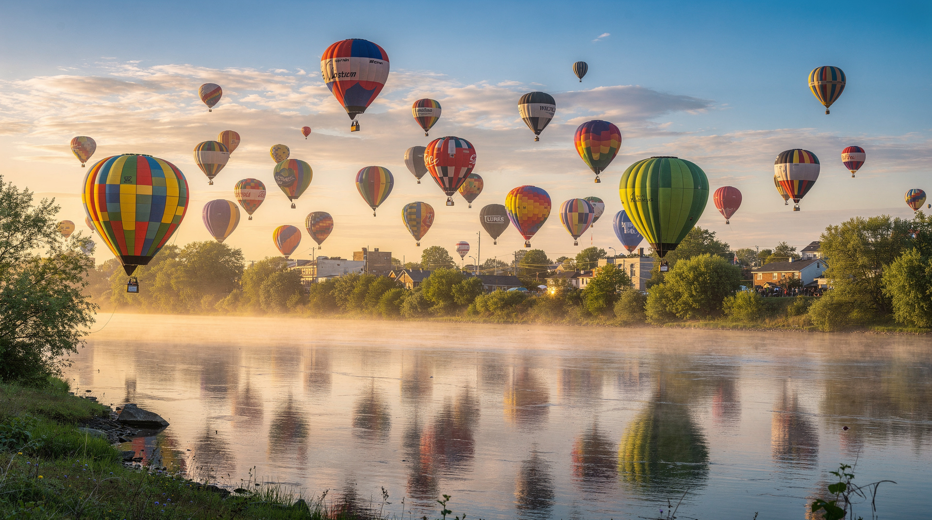
The balloon capital of the Americas
Every year in the second week of August, the skies above the Richelieu River fill with hot air balloons. Not a few dozen — hundreds. The Festival international de montgolfières de Saint-Jean-sur-Richelieu is the largest hot air balloon festival in the Americas and one of the ten largest in the world, bringing over 600 000 visitors over its ten-day run. The spectacle of 150 balloons ascending simultaneously at dusk, lit from within against a darkening sky, is the kind of thing that stays with you — genuinely extraordinary even for people who don’t consider themselves balloon enthusiasts.
The festival runs at the end of the second week and through the third weekend of August (exact dates shift by year; check the official festival website, montgolfières.com, for the current schedule). Programming includes morning and evening mass ascents (weather dependent), balloon rides (book months in advance — they sell out), night glow events where tethered balloons illuminate simultaneously, and a ground fair with local food and music.
Practical notes for the festival: parking is overwhelmed. Drive to an outlying park-and-ride and take the shuttle; the festival website provides shuttle locations each year. Accommodation in Saint-Jean books out entirely during the festival — most visitors stay in Montreal and day-trip, or camp on-site. The festival grounds are south of the city centre near the airport.
The Fort and the Richelieu corridor
The Richelieu River was one of the most strategically contested waterways in North American history. Running south from the St. Lawrence to Lake Champlain and then into New York state, it was the invasion route used in every major conflict between the French, British, and Americans from the 17th century through the War of 1812. Fort Saint-Jean (or Fort St. John, as the British called it) was established in 1748 at the point where the river meets what is now the city — rebuilt, captured, demolished, and rebuilt again through a series of conflicts over the following century.
Today the fort site is home to the Collège militaire royal de Saint-Jean, Canada’s French-language military college, and the Musée du Haut-Richelieu (182 Rue Jacques-Cartier Nord), which covers the region’s military and social history. The museum is genuinely good — not a tourist-polished production but a real regional history museum with exceptional collections of militaria and artifacts from the various conflicts that passed through this valley. Entry around 8-12 CAD; closed Mondays.
The Canal de Chambly nearby (a few km north toward Chambly) is a 19th-century canal built to allow lake boats to bypass the Richelieu rapids. It is now a National Historic Site with walking and cycling paths along its banks; the Chambly Basin at the southern end of the canal is a pleasant spot.
Lake Champlain and the border
Saint-Jean-sur-Richelieu sits at the northern tip of the Lake Champlain basin — the lake itself straddles Vermont, New York, and Quebec, with its Quebec portion accessible via the Richelieu River south of the city. The lake’s shoreline in the Montérégie region is used for recreational boating and fishing, though the most scenic stretches are in Vermont, not Quebec.
For visitors arriving from Vermont or New York state, Saint-Jean is the first significant Quebec city after the Lacolle border crossing (less than 30 km south on Route 15 / I-87). The cultural shift is immediate and startling — the signs, the architecture, the cafés, and the conversations all change within minutes of the border.
Cycling: the Route Verte connection
The Route Verte cycling network has an important corridor through the Montérégie, and Saint-Jean connects to it. Route 1 of the Route Verte follows the Richelieu River northward toward Chambly and eventually Montréal; the flat terrain and riverside scenery make it one of the more approachable cycling routes in the province for non-specialist cyclists.
Bike rentals are available in Chambly (a few km north) and occasionally in Saint-Jean during summer season. The Chambly-to-Saint-Jean stretch (roughly 12 km along the river and canal path) is a pleasant 2-3 hour return ride with café stops at the Chambly Basin.
Getting there
By car: Saint-Jean is 45 km south of Montreal on Autoroute 35, which links Montréal directly to the US border. The drive takes 45-60 minutes from downtown depending on traffic. Parking in the city centre is generally free.
By train: Exo (commuter rail) operates limited service between Montréal and Saint-Jean on the South Shore line — primarily morning and evening commuter hours on weekdays. Check exo.quebec for current schedules. The station is well-placed for the city centre. Weekend service is infrequent.
By bike: the Route Verte cycling path from Chambly (which connects to the south shore Montréal cycling network via the Chamly Canal path) is feasible for confident cyclists; allow 2-3 hours from central Montréal.
Is it worth a dedicated trip?
During the balloon festival: unequivocally yes. There is nothing comparable in Quebec and very little comparable in North America. One full day — arrive mid-afternoon, see the evening mass ascent and night glow, return to Montreal late — is the minimum meaningful experience. Two days (camping or staying in the region) allows the morning ascent as well.
Outside the festival: Saint-Jean is a pleasant provincial city with good local cafés and a real historic district, but it does not have the density of interest to justify a dedicated trip from Montreal for most travellers. Combine it with Chambly (the fort and canal basin, 15 km north) and perhaps a side trip to the Abbaye Saint-Benoît-du-Lac (45 minutes east in the Eastern Townships) for a full day in the southern Montérégie.
The Montérégie region overview on the Montérégie page covers Mont-Saint-Hilaire (hiking), the apple orchards of the Rougemont circuit, and the other towns in this agricultural region that rarely appear in generic Quebec travel guides.
Practical notes
- Language: Saint-Jean is a Francophone city. Menus and street signs are in French; English is understood in hotels and restaurants frequented by tourists, but less consistently than in Montréal.
- Budget: noticeably cheaper than Montréal for accommodation and meals. Hotel rooms during the balloon festival are the exception — prices triple and availability is nil close to the festival dates.
- Currency: CAD; standard 15% tax on goods and services.
- Combining with the Eastern Townships: Saint-Jean is the logical southern entry point for the Montérégie before looping east into the Eastern Townships (Cantons-de-l’Est). The drive from Saint-Jean to Magog takes about 1h30 via Routes 35 and 10 Est.