Nord-du-Québec & Nunavik
Quebec's vast subarctic north: 1.7M km², 14 Inuit villages, Kuujjuaq as gateway, polar bears on Hudson Bay, and northern lights actually visible.
Updated:
Quick facts
- Area
- 1.7 million km² (larger than France and Spain combined)
- Population
- ~13 000 people across 33 communities
- Inuit villages
- 14 (Nunavik territory)
- Access to Kuujjuaq
- Air Inuit from Montréal (YUL), 2.5h flight
- Cree territory
- Eeyou Istchee (southern part), 9 Cree communities
A note on GetYourGuide coverage
Nord-du-Québec and Nunavik have no GetYourGuide listings. Organised tours in this region are available only through specialised outfitters and Inuit community organisations, often booked months in advance and at significant cost. This page explains what the region is, who it’s for, and how to plan a visit honestly.
What you need to know before reading further
Nord-du-Québec is not a tourism destination in the conventional sense. It covers 1.7 million square kilometres — larger than France and Spain combined — and is home to roughly 13 000 people scattered across 33 communities. There are no highway connections; every community is accessed by air, and some by winter ice road. Accommodation is limited, expensive, and often requires booking through community organisations or government contractors. Daily costs of 400-700 CAD are normal even for modest lodging and meals.
This is for a specific kind of traveller: one who has a genuine reason to be here — whether that’s observing Inuit culture and traditional practices with permission and respect, hunting or fishing with a licensed outfitter, experiencing aurora borealis above the Arctic treeline, or witnessing polar bears on Hudson Bay. For that traveller, Nord-du-Québec offers experiences unavailable anywhere else on Earth at comparable accessibility.
For the traveller who wants a taste of remote Quebec without this level of commitment, the Côte-Nord region, the Saguenay Fjord, or the Gaspésie backcountry provide genuine wilderness without the logistical extreme.
The territory: Nunavik and Eeyou Istchee
Nord-du-Québec is divided between two Indigenous territories with distinct peoples and histories:
Nunavik occupies the northern third of the province, above the 55th parallel. It is home to 14 Inuit communities including Kuujjuaq (the administrative capital), Inukjuak, Puvirnituq, and Kangiqsujuaq. The Inuit have inhabited this territory for approximately 4 000 years; Nunavik became a self-governing entity through the James Bay and Northern Quebec Agreement of 1975, which remains one of the foundational Indigenous land agreements in Canadian history.
Eeyou Istchee covers the southern portion of Nord-du-Québec, east of James Bay. It is the traditional territory of the Cree Nation (Eeyou Istchee), comprising nine Cree communities including Chisasibi, Mistissini, and Nemaska. The Cree have a separate political structure from the Inuit and maintain different cultural traditions, land relationships, and governance.
These are not interchangeable — a visit to Kuujjuaq (Inuit) is fundamentally different from a visit to Chisasibi (Cree). Both require cultural sensitivity, advance preparation, and ideally contact with community tourism offices before arrival.
Kuujjuaq: the gateway
Kuujjuaq (population ~2 800) is the largest community in Nunavik and the administrative entry point for most visitors. Air Inuit operates flights from Montréal-Trudeau (YUL) roughly twice daily; the flight takes approximately 2.5 hours. Return flights cost 600-1 200 CAD depending on availability and timing — these are not discount routes.
Kuujjuaq sits on the Koksoak River, which drains the Ungava Peninsula into Ungava Bay. The river is one of the best char fishing rivers in North America, which draws licensed fishing outfitters and their clients during summer. The town has a hotel (Auberge Kuujjuaq, government-standard accommodation), a Northern Store (the dominant retailer in isolated northern communities), a health centre, and a small cultural centre.
The Musée Nunnavik in Kuujjuaq documents Inuit history and contemporary culture in the region. It is modest in scale but genuine in content. If you arrive without a specific outfitter or programme, the museum is a good first stop.
From Kuujjuaq, outfitters can arrange access to the tundra, river fishing, and in late autumn and winter, polar bear observation. Kuujjuaq is approximately 1 300 km north of Montréal by straight line.
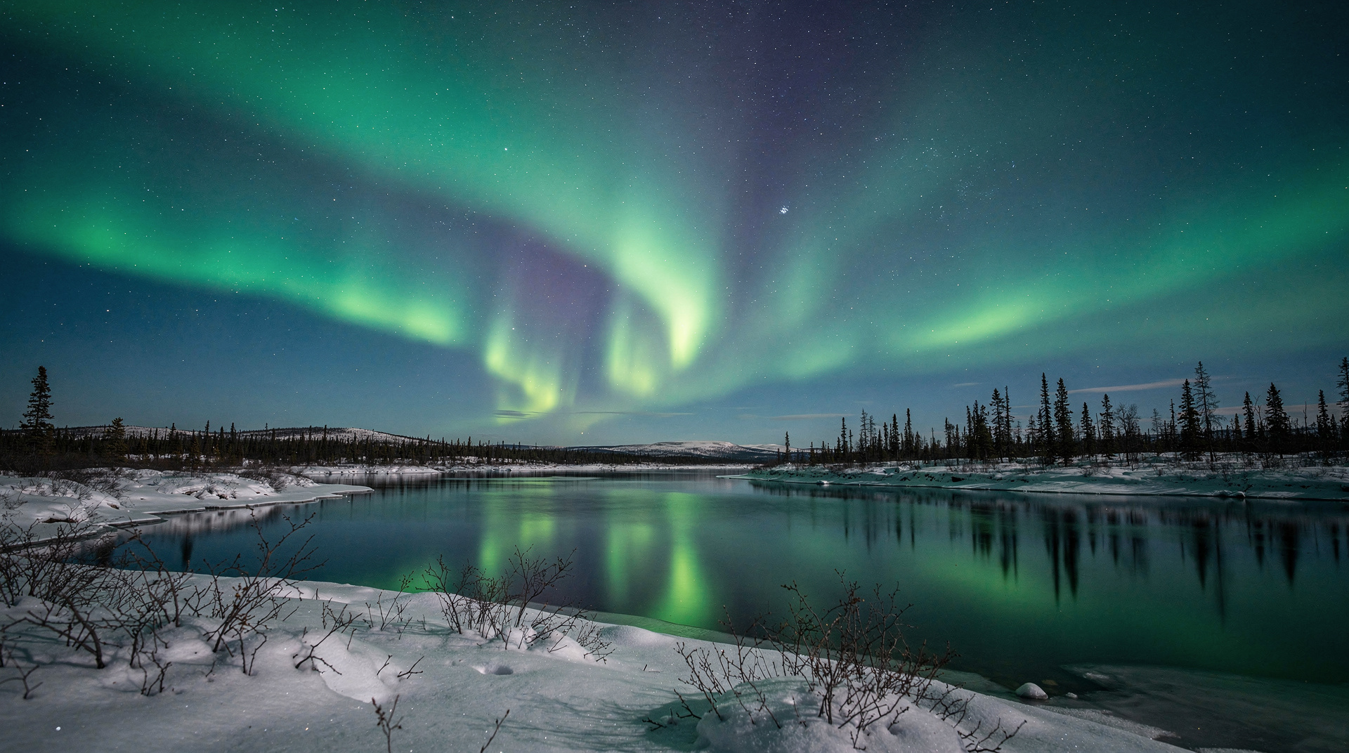
Northern lights: the honest assessment
Northern lights are visible from Nord-du-Québec. This needs to be stated plainly because southern Quebec marketing sometimes implies aurora borealis is accessible from Québec City or the Laurentides — it is not, or only marginally so. The auroral oval sits over the Hudson Bay region; Kuujjuaq and the communities around it have genuine, reliable aurora viewing from September through April, with the best conditions in late winter when nights are long but temperatures survivable.
Southern Quebec — Montréal, Québec City, even Saguenay — occasionally sees aurora during geomagnetic storms (Kp index 5+), perhaps 5-10 nights per year. It is not a reason to plan a trip south of the 50th parallel. If aurora viewing is your primary purpose, Nord-du-Québec is the honest answer within Quebec.
For aurora viewing at the treeline: the period March-April combines the longest useful dark hours with temperatures that are cold (-20 to -35°C at night) but manageable with appropriate equipment. July-August has midnight sun above the Arctic Circle at these latitudes — no aurora.
Polar bears: Hudson Bay
The western coast of Nunavik along Hudson Bay — particularly around Inukjuak — sees polar bear activity, especially in autumn as the sea ice forms. This is not a Churchill, Manitoba-style bear tourism industry; there are no dedicated bear-viewing tour operators based in Nunavik at the scale that Churchill operates. Viewing is possible through relationship with local outfitters and community guides, but it requires advance arrangement through community organisations.
The polar bears here are part of the Hudson Bay subpopulation, which scientists have documented as declining due to reduced sea ice. This context matters: visiting with a local Inuit guide who monitors the bears and their condition gives you information that a generic wildlife tour cannot.
Beluga whales near Kuujjuaq
The Koksoak River estuary at Kuujjuaq is one of the more accessible places in Quebec to observe beluga whales. Belugas feed in the estuary during summer (July-August), visible from shore or from small boats with local guides. This is not a commercial whale-watching operation in the Tadoussac sense — it requires local contacts and is weather and season dependent.
For comparison: Tadoussac offers far more reliable and commercially organised whale watching (May-October), including blue whales, minke whales, and humpbacks, with multiple operators and no complex logistics. Nunavik’s beluga observation is for those already in the region, not a primary reason to come.
How to plan a visit responsibly
-
Contact community tourism offices first. The Kativik Regional Government (krg.ca) maintains tourism information for Nunavik. Nunavik Tourism (nunavik-tourism.com) provides outfitter listings and practical guidance.
-
Book outfitters months in advance. Summer fishing lodges and winter aurora/bear viewing packages are limited in capacity and often require 6-12 months lead time.
-
Budget conservatively. A 7-day guided visit to Nunavik costs 3 000-7 000 CAD per person all-in (flights, accommodation, guide services), sometimes more for specialised activities. This is not the budget-friendly part of Quebec travel.
-
Cultural protocols: Inuit and Cree communities have their own protocols around photography, land access, and traditional practices. Ask before photographing individuals. Do not enter communities and immediately start photographing without introduction.
-
Health and emergency: the nearest hospital-level facility from most Nunavik communities is Montréal. Medevac exists but is expensive and weather-dependent. Travel insurance with medical evacuation coverage is non-negotiable.
James Bay and the hydroelectric project
The La Grande complex — the hydroelectric project that flooded vast areas of Eeyou Istchee from the 1970s onward — is one of the largest engineering projects in human history. The La Grande reservoir network has an area comparable to Switzerland. Hydro-Québec operates facilities tours (Robert-Bourassa generating station, accessible by chartered flight or road from Chibougamau), though these are primarily for professional and educational groups rather than casual tourists.
The James Bay hydroelectric project remains politically and culturally complex. The 1975 James Bay Agreement was signed under contested circumstances; its legacy among Cree and Inuit communities is mixed. Any engagement with this history as a visitor should acknowledge this complexity honestly.
Connecting with adjacent regions
Nord-du-Québec has no road connection to the rest of the Quebec highway system north of approximately the 50th parallel. The James Bay Road (Route de la Baie James) runs north from Matagami (reachable by car from Montréal in ~7 hours) to Radisson/La Grande; this is the only road access into the Cree territory portion of Eeyou Istchee. It is a 620-km gravel and paved road through boreal forest with fuel stops only at Km 381. The drive requires preparation and a vehicle with good ground clearance.
For visitors approaching from the south by road, the Abitibi-Témiscamingue region is the logical starting point before heading north toward James Bay.