Parc national de la Mauricie
Shield lakes, moose at dawn, and canoe portages through old-growth forest — the most accessible wilderness national park between Montreal and Quebec City.
Updated:
Quick facts
- Distance from Montreal
- 230 km (2h40 by car)
- Distance from Quebec City
- 200 km (2h30 by car)
- Distance from Trois-Rivières
- 65 km (1h by car)
- Park area
- 536 km²
- Canoe circuit
- 82 km Rivière Cachée loop (4-5 days)
Canada’s Laurentian Shield in miniature
Parc national de la Mauricie was one of the first national parks east of the Rockies, established in 1970 when it became clear that the Laurentian Shield wilderness north of Trois-Rivières needed federal protection from logging and cottage development. The decision proved correct: the park now preserves a 536 km² mosaic of lakes, wetlands, boreal forest, and exposed granite that serves as a reference landscape for what most of Quebec’s interior once looked like.
The park is the best single day or weekend outdoor destination between Montreal and Quebec City. Its accessibility — 2h40 from Montreal, 2h30 from Quebec City — and the quality of its infrastructure (well-maintained portages, good campgrounds, outfitter rentals) make it approachable for families and serious paddlers alike.
Getting into the park
Two main entrances:
- Saint-Mathieu-du-Parc (west): main entrance, visitor centre, canoe rentals, most campgrounds. The typical choice for visitors coming from Montreal.
- Shawinigan (south): smaller entry point, closer to the park’s southern lakes, better for day hikers from Trois-Rivières.
Entry fee: 10.50 CAD/adult/day, 21 CAD/family. Parks Canada Discovery Pass (150 CAD, covers all national parks for 12 months) is good value if visiting multiple parks in the same trip.
Park hours: the main roads are accessible 24h in summer. The visitor centres are open 8h-18h mid-May to mid-October; 9h-16h in shoulder season.
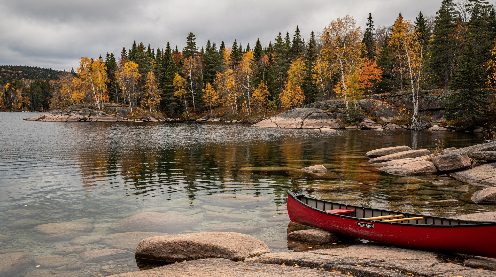
Canoeing
The park’s interior lake circuit is what serious paddlers come for. The Rivière Cachée loop (82 km, 15 portages, 4-5 days) connects 8 lakes through old-growth forest with no motorized boats permitted in the interior. Backcountry permits and portage routes are managed by Parks Canada; book through the reservation system months ahead for July-August.
For day visitors, the Lac Wapizagonke circuit is excellent: a 26 km paddling and portage route that can be done in a long day or split over 2 days with a campsite. The outfitter at Masson Beach rents canoes (35 CAD for 2h, 70 CAD for the day, including life jackets and paddles) and kayaks (25-40 CAD).
Tip: the morning paddle on Lac Wapizagonke from Masson Beach to the northern end of the lake (5 km one way, flat water) is consistently peaceful and often produces moose sightings at the marshy inlets. Allow 2-3 hours round-trip.
Hiking
The park has 160 km of hiking trails across varying difficulty levels.
Lac Solitaire trail (10 km, moderate, 4-5 hours): the park’s best day hike, circling a lake with several viewpoints over the surrounding forest and a beach for a swim at the midpoint. Trail surface is rocky in sections; hiking boots recommended.
Wapizagonke trail (north): a trail following the eastern shore of the lake for 8 km (one-way) with view platforms. Can be hiked one-way with a canoe shuttle from the outfitter (ask at Masson Beach).
Sentier de la Roche (3.5 km, easy): short loop near the Saint-Mathieu entrance, good for families with young children. Interpretive panels on park geology.
Sentier des Deux-Criques (21 km, challenging, 2 days): the park’s longest trail, requiring an overnight at the backcountry campsite midway. Views over the shield plateau.
Camping
Front-country campgrounds (accessible by car):
- Rivière Waber: 100 sites near the south entrance, electrical hookups available, 32-45 CAD.
- Lac Bouchard: 100 sites, no electricity, closer to interior trails, 25-32 CAD.
- Parent Beach (Plage Parent): 50 sites near a swim beach, popular with families.
All campgrounds are reservable through Parks Canada’s reservation system (reservation.pc.gc.ca). July-August weekends fill within minutes of the reservation window opening in early April.
Backcountry campsites: located along the interior canoe and hiking routes. Reservations required (200 sites spread across the interior). 22-28 CAD/person/night. Portable water filters required; no open fires in the interior.
Winter activities
The park operates year-round, and winter is genuinely underutilized:
Cross-country skiing: 87 km of groomed trails, ranging from beginner loops to the challenging 18 km circuit around Lac à la Pêche. Trail access included in park entry. Equipment rental available at the welcome centre (35-50 CAD/day).
Snowshoeing: the hiking trails become snowshoe routes; rental snowshoes available at the welcome centre.
Ice fishing: possible on designated lakes with a Quebec fishing permit (15 CAD/day for non-residents, available at the welcome centre). Ice huts can be rented.
Wildlife calendar
June: moose cows and calves visible at dawn near wetlands; loons calling on interior lakes; black bears active.
July-August: peak activity, peak wildlife. Best canoe weather. Dawn drives on park roads for moose and beaver.
September: bull moose in rut (audible at dawn — the haunting bugling call is unmistakable). Foliage begins. Significantly quieter than summer.
October: peak foliage, cool temperatures. Park services reduce after mid-month.
February-March: cross-country skiing season peak. Fresh snow, lower crowds, crisp air.
Services in the park
Masson Beach outfitter: canoe, kayak, paddleboat and stand-up paddleboard rentals; canoe portage service (shuttles boats between lakes for multi-day circuits); basic provisions.
Welcome centre (Saint-Mathieu entrance): park maps, trail conditions, bear sighting board, interpretive exhibits. Worth 30 minutes.
Campfire wood: sold at campgrounds (approximately 10 CAD/bundle). Open fires permitted only in designated fire rings from mid-May to October, subject to fire ban conditions.
Getting there
From Montreal (Saint-Mathieu entrance): Autoroute 40 to exit 217, then Route 55 North toward Grand-Mère, then Route 155 North to Saint-Mathieu-du-Parc. 230 km, 2h40.
From Quebec City: Autoroute 40 West toward Trois-Rivières, exit 220, then north on Routes 55 and 155. 200 km, 2h30.
From Trois-Rivières: Route 55 North to Saint-Mathieu-du-Parc. 65 km, 1h.
There is no public transit to the park. A rental car or organized tour from Trois-Rivières is required.
Combining with other destinations
The park is the centrepiece of the Mauricie region. From the park, Trois-Rivières is 1h south — a practical combination for a 2-night visit: arrive in Trois-Rivières, explore the city, day-trip to the park, overnight at a campground or the inn at Saint-Mathieu-du-Parc.
For the bigger picture, see the Quebec road trip itinerary which includes a Mauricie stop between Montreal and Quebec City. The Quebec parks guide compares the Mauricie with other provincial and national parks.