Chic-Chocs Mountains
Quebec's highest peaks above the treeline: caribou herds, via ferrata, and moose-filled boreal forest in the Parc national de la Gaspésie.
Updated:
Quick facts
- Highest peak
- Mont Jacques-Cartier (1 268 m)
- Caribou herd
- Gaspésie caribou — Quebec's southernmost wild herd
- Base town
- Sainte-Anne-des-Monts (park entrance)
- Distance from Gaspé
- 180 km (2h by car)
- Distance from Quebec City
- 450 km (4h30 by car)
Quebec’s alpine wilderness
The Chic-Chocs are what most visitors to the Gaspé Peninsula discover only by accident — a chain of rounded summits rising above the treeline along the peninsula’s interior spine, holding snow into June and sheltering Quebec’s southernmost wild caribou herd. The mountains are not high by alpine standards (Mont Jacques-Cartier tops out at 1 268 m), but the combination of latitude, maritime climate, and relative isolation gives the high plateau a genuinely subarctic character.
The primary access point is Sainte-Anne-des-Monts, a modest fishing town on the St-Lawrence north shore, 180 km from Gaspé and 450 km from Quebec City. The Parc national de la Gaspésie entrance and the Gîte du Mont-Albert (the park’s legendary backcountry lodge) are 40 km inland from Sainte-Anne-des-Monts via Route du Parc.
The Chic-Chocs are not a theme-park experience. The trails are serious, the weather is changeable, and the isolation is real. This is what makes them extraordinary.
The park: Parc national de la Gaspésie
The provincial park (not federal — different from Forillon) covers 800 km² of the Chic-Chocs and McGerrigle ranges. Entry fees apply: approximately 10 CAD/adult/day or 42 CAD for an annual Réseau Sépaq pass (best value if visiting multiple provincial parks).
The park has three distinct zones: the alpine ridge above the treeline (accessible July-September, weather permitting), the sub-alpine zone of krummholz spruce, and the boreal forest of the lower valleys. The altitude transitions are visible in a single day hike from the valley to the summit.
Mont Jacques-Cartier (1 268 m)
The highest summit in Quebec outside the Laurentian Mountains. A 9 km round-trip trail from the Secteur Mont-Jacques-Cartier trailhead (elevation gain 600 m, 4-5 hours) leads to the plateau and summit. The last 2 km cross the tundra — blueberry heath, Labrador tea, and exposed quartzite — at an angle that feels significantly more than its statistics suggest.
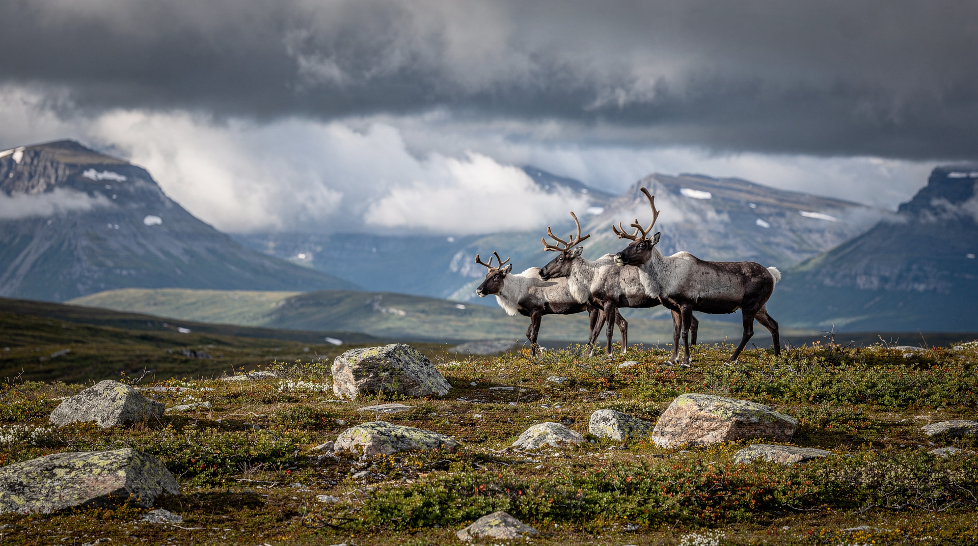
Caribou: the Gaspésie woodland caribou herd (currently approximately 50-70 animals, one of the most critically endangered herds in eastern North America) spends summer on the high plateaus to escape insects and predators. Sightings at the summit plateau are common in July-August but not guaranteed. Parks Canada asks visitors to maintain a 50 m distance and to stay on the trail through the tundra.
The summit gives a 360° panorama: the St-Lawrence to the north, more mountains in every other direction, and on the clearest days, Anticosti Island as a thin line in the gulf.
Mont Albert (1 154 m) and the Gîte
Mont Albert is the more accessible summit — a 18 km loop trail from the Gîte du Mont-Albert (full day, 6-8 hours, significant elevation). The Albert plateau is ringed by cliffs that drop sharply to the valley; the view of the Rivière Sainte-Anne below is one of the park’s best. The trail is rated “difficult” — appropriate for fit hikers, not beginners.
Moose: the valley around the Gîte has one of the highest moose densities in Quebec. Dawn and dusk walks along the gravel road between the park entrance and the Gîte regularly produce sightings.
Via ferrata at Mont Ernest-Laforce
A via ferrata route was installed on Mont Ernest-Laforce in the park — iron rungs and cables on the cliff face, no prior technical climbing experience required. Groups are guided; book at the park visitor centre. Duration approximately 3-4 hours, cost 70-90 CAD. The route is open July to September and limited to 8 participants per departure. Advance booking in July-August is essential.
The Gîte du Mont-Albert
The park’s main accommodation (and the reason many people come) is the Gîte du Mont-Albert — a 1950s lodge rebuilt and expanded over the decades, with rooms, chalets, and a dining room that serves genuinely good food. This is not glamping; the beds are comfortable, the service is personal, and the setting — in the boreal forest with mountains on all sides — is perfect.
Rooms run 150-250 CAD/night (breakfast included in some packages). Chalets with kitchen facilities run 250-350 CAD. July-August weekends book out months in advance. The dining room is open to non-guests for dinner (35-60 CAD per person, reservation required); the menu focuses on regional ingredients and Quebec cuisine.
Booking: sépaq.com or by phone; open from late May. No walk-in availability in July-August.
Camping in the park
The park has three campgrounds:
- Rivière Sainte-Anne (near the Gîte): serviced sites, 30-45 CAD, open May-October.
- Lac-Paul (remote): wilderness sites accessible on foot or by canoe, 22-28 CAD.
- Backcountry huts: several refuges along multi-day routes, 28-35 CAD/person/night; book via sépaq.com.
Sainte-Anne-des-Monts: the gateway town
The town of Sainte-Anne-des-Monts has limited but functional services: grocery store, pharmacy, fuel, and several restaurants. The waterfront has a small marina and views across the St-Lawrence toward the Haute-Côte-Nord.
Exploramer: a marine science centre in Sainte-Anne-des-Monts with aquarium exhibits on Gulf species and a small beach. Good for families with children on a rainy afternoon. Admission approximately 15 CAD.
Restaurant L’Anse aux Coques: the best restaurant in town, with good seafood and a terrace view, 30-50 CAD per person.
When to go
July-August: best for summit hiking and caribou sightings. Warmest temperatures (12-18°C at altitude). Busiest period — book the Gîte months ahead.
September: foliage begins on the lower slopes; caribou remain on the plateau. Weather increasingly unstable. The Gîte is quieter.
Late September-October: the foliage peaks and the crowds vanish. Summit hiking becomes risky after September 15 due to sudden snowfall; check trail conditions with park staff.
Winter: the park stays open for cross-country skiing and snowshoeing, with groomed trails. The Gîte operates year-round. Winter access to summits requires experience with alpine conditions.
Getting there
From Sainte-Anne-des-Monts (on Route 132): 40 km south on Route du Parc to the park entrance. The road is paved.
From Gaspé: 180 km west on Route 132 (north shore), 2h.
From Quebec City: 450 km east on Routes 132/138 through Rivière-du-Loup and the north shore, 4h30-5h.
There is no public transit to the park. A car is essential.
Combining with other destinations
The Chic-Chocs are the climax of the north-shore leg of the Gaspé Peninsula loop. After Forillon and Gaspé town, continue west on Route 132, stopping at Grande-Vallée and Mont-Louis for the scenery, before turning south at Sainte-Anne-des-Monts toward the park.
For hikers who want to extend the mountain experience, the Gaspésie hiking guide covers the park’s multi-day trails. The Gaspé Peninsula road trip itinerary places the Chic-Chocs in context of the full loop.