Gaspésie loop 7 days
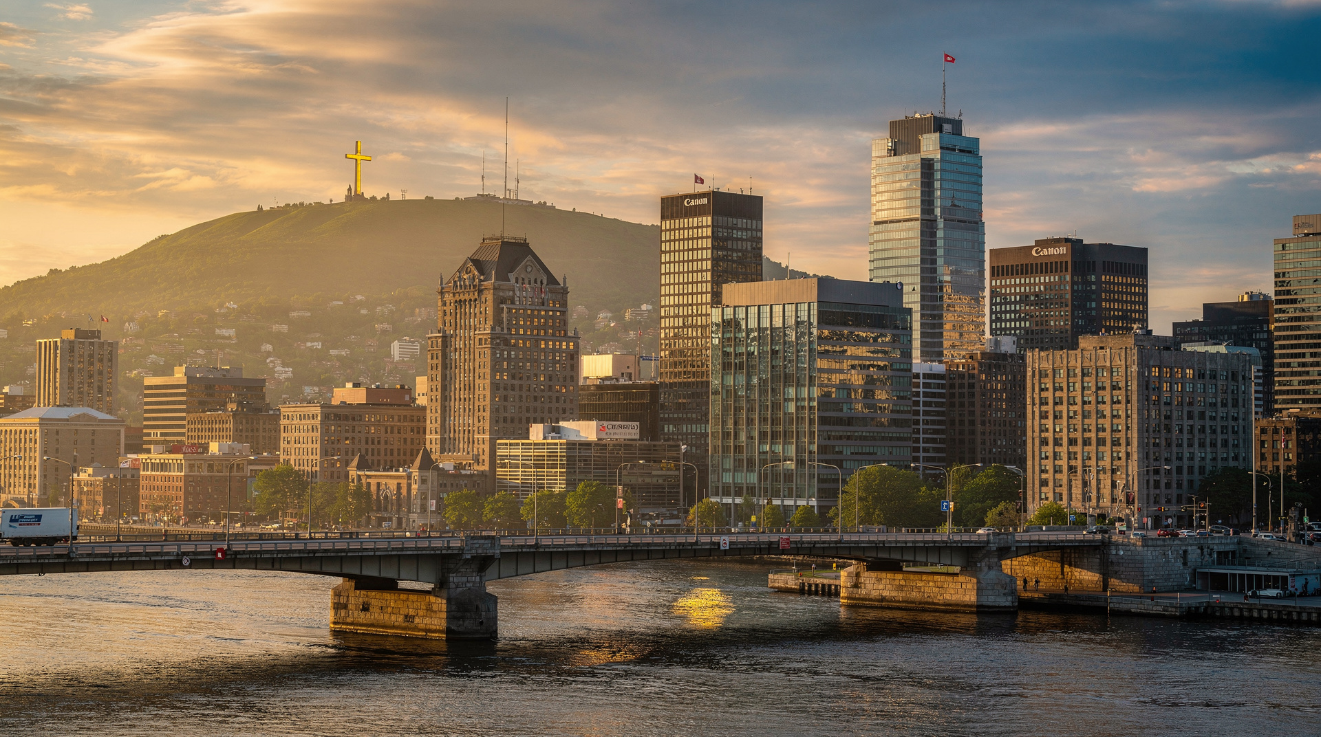
3-Day Gaspésie Trip from Montreal
Duration: 3 days
Why the Gaspésie is Québec’s great road trip
Ask any Québécois which part of their province is most worth crossing the entire country to see, and most will say the Gaspésie. The peninsula — a 1 300-km circuit jutting into the Gulf of Saint-Laurent — has a landscape that stops conversations: cliffs dropping directly into the sea, the surreal Rocher Percé standing offshore, mountains that feel like the Scottish Highlands pushed into the Atlantic, and a French-Canadian culture that survived 400 years of isolation to remain utterly itself.
The Gaspésie is not near anything. Montréal to Percé is 950 km. Plan accordingly. This 7-day loop is designed to start and end in Québec City (a 5h30 drive from Percé, or a 9h drive from Montréal), making it a standalone trip rather than a sideshow. Alternatively, access the peninsula directly via the guided 3-day Gaspésie trip from Montréal , which handles all transport logistics.
Season: June to early October. Forillon National Park closes to camping in October, and many peninsula services close by mid-October. Whale watching (available at Sainte-Anne-des-Monts and Forillon) runs May-October.
Day 1: travel to Gaspésie — Québec City to Sainte-Flavie
Drive: Québec City → Sainte-Flavie = 300 km, ~3h30 via Autoroute 20 east. This is the access drive rather than the scenic section — the Autoroute follows the south shore of the Saint-Laurent through Rivière-du-Loup and Rimouski before reaching Sainte-Flavie, where the Gaspé Peninsula begins.
Stop in Kamouraska (a beautiful heritage village at km 180) for lunch — the village’s main street of stone houses and the church facing the river is one of the most photographed views on the south shore. In Rimouski, the Musée naval is worth 45 minutes for the story of the Empress of Ireland (the 1914 shipwreck that killed more Canadians than the Titanic).
Arrive Sainte-Flavie by late afternoon. The entry to the Gaspésie is marked by the Continental Divide at Sainte-Flavie — here the peninsula’s spine of mountains becomes visible inland. Overnight in Matane (50 km further east, good selection of accommodation) or continue to Sainte-Anne-des-Monts.
Day 2: the Chic-Chocs and Haute-Gaspésie
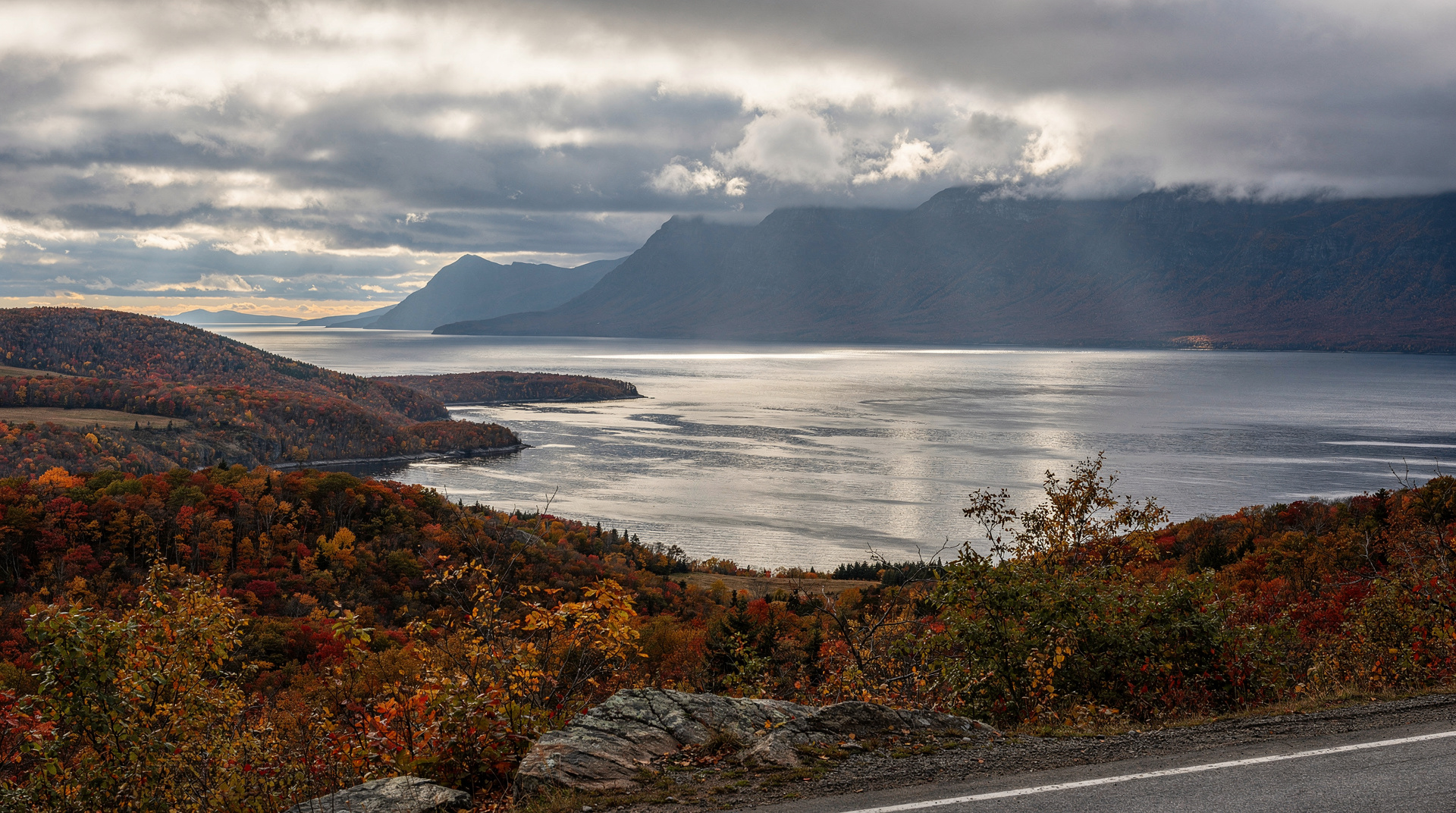
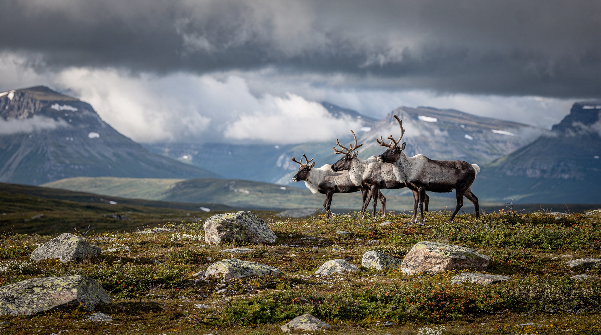
Sainte-Anne-des-Monts. The access point for the Chic-Chocs Mountains and Parc national de la Gaspésie is 30 km south via Route 299. This park protects the summit plateau of the Gaspésie highlands — the only place south of the Arctic with a caribou herd, and the highest peaks in Québec south of Nunavik (Mont Jacques-Cartier, 1 268 m; Mont Albert, 1 154 m).
Morning hike — Mont Albert. The Mont Albert circuit (21 km, 6-7 hours) crosses an arctic-alpine plateau of extraordinary strangeness — the ultramafic rock chemistry means the summit vegetation is sub-Arctic tundra 800 km south of the treeline. Moose and caribou are commonly seen. Alternatively, take the shorter Sentier des Loups (8 km, 3 hours) to the Albert plateau edge for the views without the full circuit.
Afternoon — return to coast and drive east. Continue on Route 132 north shore through the fishing villages of Cap-Chat and Sainte-Anne-des-Monts. Stop for fresh seafood at one of the quayside stands. The road offers views across the Gulf to the New Brunswick coast on clear days.
Overnight — Sainte-Anne-des-Monts or Gaspé. Gaspé (capital of the peninsula, 200 km from Sainte-Anne) is the better overnight base if you want to reach Percé efficiently on Day 3. Drive time from Sainte-Anne to Gaspé: 2h30.
Day 3: Gaspé and Percé — the icons
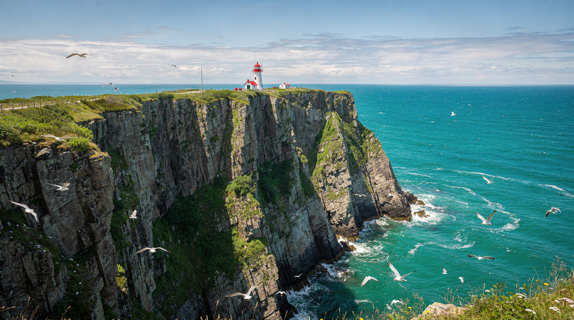
Drive: Gaspé → Percé = 75 km, 1h. The drive between Gaspé and Percé along Route 132 is one of the most dramatic road sections in eastern Canada — the road clings to cliff edges above the turquoise gulf, with the Rocher Percé appearing on the horizon 30 km before arrival.
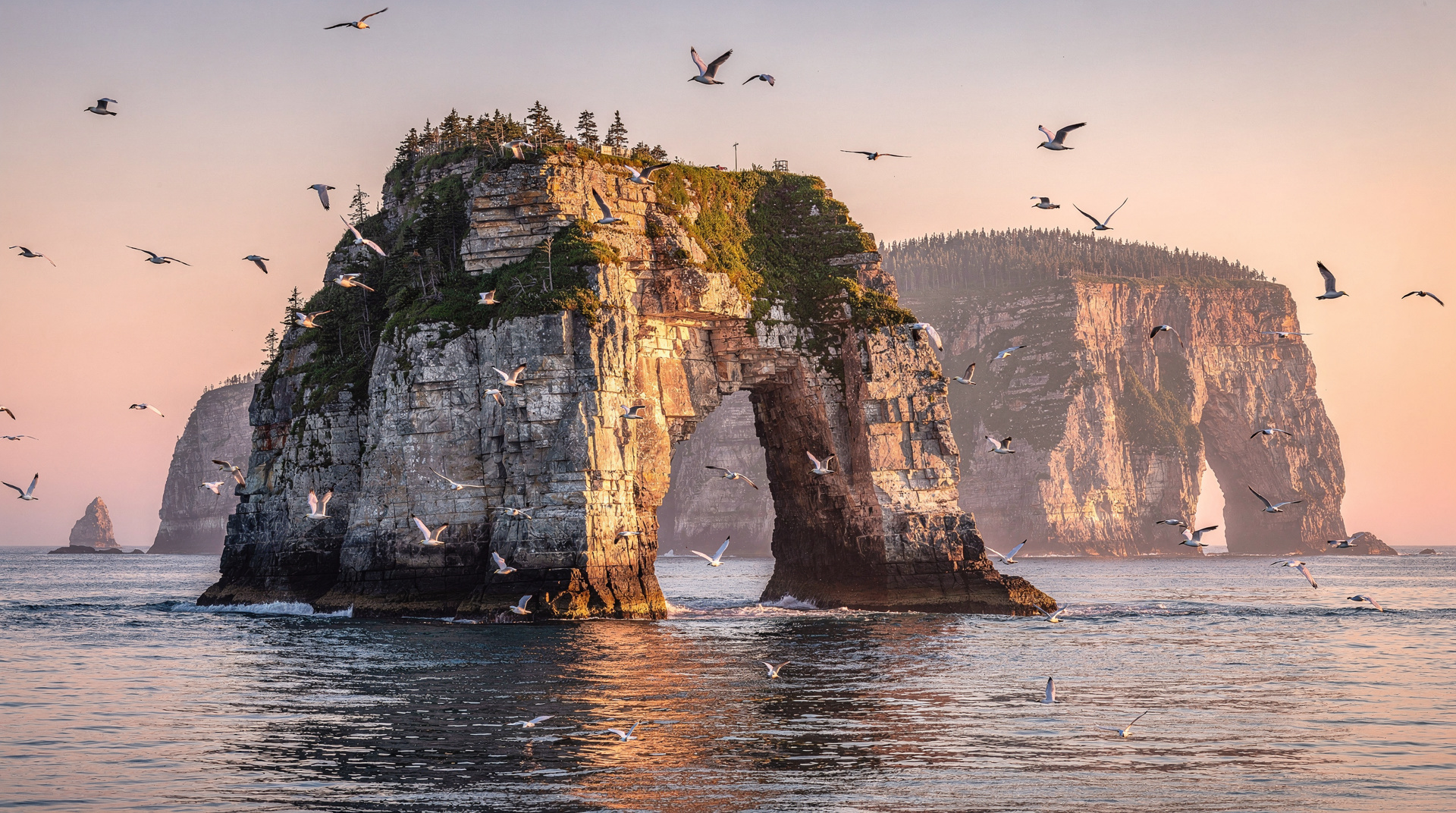
The Rocher Percé. The 400-metre limestone sea stack with its massive natural arch is the defining image of Gaspésie. At low tide (check tidal schedules — essential), the tidal flat allows you to walk within 50 metres of the rock. The crossing is only safe for a 2-3 hour window around low tide. Watch for the tidal schedule posted at the Percé visitor information office.
Île Bonaventure. The boat to Île Bonaventure (every 30 min in summer, 20 min crossing, 30-40 CAD return) takes you to one of the world’s great seabird colonies. The island hosts 60 000 northern gannets nesting on its cliffs — a wall of white birds stacked from the waterline to the clifftop, a constant noise of calling adults, and the spectacle of hundreds diving for fish simultaneously. The 3-km hike across the island through the nesting colony is extraordinary. Allow 3-4 hours for the full island experience.
Evening — Percé village. The village has a strip of restaurants facing the Rocher. La Maison du Pêcheur is the most acclaimed (fresh local seafood, excellent); Les Failles is the best for sunset views. Budget 60-90 CAD per person. Book in advance in July-August.
Day 4: Percé surroundings and Forillon approaches
Morning — Percé Geopark. The cliffs around Percé are a UNESCO Global Geopark recording 500 million years of ocean floor geology. The cliff walking trails above the village offer the most dramatic overhead views of the Rocher Percé and Île Bonaventure. The 2-km Sentier des Failles (Fault Trail) follows a rock face with exceptional geological formations.
Late morning — drive to Forillon. Route 132 from Percé north rounds Cap d’Espoir (excellent viewpoint over the Chaleur Bay) before entering the Forillon National Park zone near Cap-des-Rosiers. Drive time: 1h15.
Afternoon — Cap-Bon-Ami. The Cape Bon-Ami trail (7 km return, 2.5 hours) follows the cliff edge above the Gulf of Saint-Laurent from the national park’s north entrance. The views from the headland are extraordinary — the cliff below hosts thousands of seabirds (murres, razorbills, kittiwakes), harbour seals on the offshore rocks, and porpoises regularly visible from the headland.
Overnight in or near Forillon. Camping in the park (10.50 CAD/person per night) is one of the best experiences on the peninsula. Alternatively, the nearest gîtes and auberges are in Grande-Vallée (30 min north) or Gaspé (1h south).
Day 5: Forillon and departure toward north shore
Morning — Cap Gaspé hike. The trail to Cap Gaspé (15 km return, 4 hours) takes you to the literal end of the peninsula — the point where the land ends and the Gulf begins. The trail passes through boreal forest (moose are common at dawn), emerges onto coastal headlands, and terminates at an interpretive panel marking the farthest eastern point of the Appalachian range. This is one of the great accessible hikes in Québec.
Midday — departure north. After the hike, drive north out of Forillon and switch to the north shore Route 132. This side of the peninsula is less visited than the south shore but arguably more dramatic — the mountains come closer to the water, the villages are smaller and more isolated, and the scenery at Cap-Chat and Sainte-Anne-des-Monts is superb.
Overnight — Matane or Mont-Joli. Matane (2h from Forillon) has the best overnight options on the north shore. The Matane-Baie-Comeau ferry (seasonal, 2h crossing) connects to the north shore of the Saint-Laurent if you want to complete a full loop via Tadoussac.
Day 6: north shore drive and return
Morning — Matane to Sainte-Flavie. The final 100 km of the peninsula’s north shore drive passes through the most isolated section of the Gaspésie — small fishing villages, river-mouth harbours, and views across the increasingly narrow Gulf toward the northern shore. The salmon rivers (Matane, Cascapédia, Nouvelle) that empty here support some of the best Atlantic salmon fishing in North America.
Midday — cross to Bas-Saint-Laurent. At Sainte-Flavie, rejoin Autoroute 20 west toward Québec City or Montréal. Alternatively, take the Route 132 west through the south shore of the Bas-Saint-Laurent for the more scenic return — villages of Trois-Pistoles, Rivière-du-Loup, and Kamouraska offer pleasant final stops.
Overnight — Rivière-du-Loup or Lévis. The Bas-Saint-Laurent has good accommodation options at Rivière-du-Loup or Kamouraska for those who prefer not to arrive in Québec City late. Otherwise, Autoroute 20 continues directly to Québec City (4h from Sainte-Flavie).
Day 7: return to Québec City or Montréal
Drive from overnight stop to your departure city. From Rivière-du-Loup:
- To Québec City: 200 km, 2h
- To Montréal: 450 km, 5h
Allow extra time for a stop at Parc national du Bic (50 km west of Rimouski) — one of the most scenic parks in Québec, with coastal trails and seal-watching from the headlands.
Drive distances — Gaspésie loop from Québec City
| Leg | Distance | Drive time |
|---|---|---|
| Québec City → Sainte-Flavie | 300 km | 3h30 |
| Sainte-Flavie → Gaspé | 300 km | 3h30 |
| Gaspé → Percé | 75 km | 1h |
| Percé → Forillon NP | 80 km | 1h15 |
| Forillon → Matane (north shore) | 230 km | 2h30 |
| Matane → Rivière-du-Loup | 260 km | 3h |
| Rivière-du-Loup → Québec City | 200 km | 2h |
| Total loop | ~1 445 km |
Budget estimate for 7 days
| Category | Mid-range (CAD) per person |
|---|---|
| Accommodation (7 nights, shared) | 700-1 050 |
| Rental car (7 days) | 280-400 (split) |
| Fuel (~1 445 km) | 130-180 (split) |
| Meals | 600-800 |
| Park fees | 60-80 |
| Île Bonaventure ferry | 30-40 |
| Activities | 200-300 |
| Total | 2 000-2 850 |
When to do the Gaspésie loop
June: The ideal month. Long days, gannets on Bonaventure just beginning to nest, lupins flowering along the roadside, cool temperatures. Not yet peak season so accommodation available without weeks-ahead booking.
July-August: Peak season. Warmest weather, full tourist services, Île Bonaventure at peak colony. Book accommodation 4-6 weeks in advance.
September: Outstanding. Fall colours begin in the Chic-Chocs (late September), fewer tourists, lower prices, full wildlife activity. Strongly recommended.
October: The park closes to camping on October 15, and Île Bonaventure boat tours end mid-October. The north shore can be stormy. Not recommended for this itinerary.
Top experiences
Bookable activities with verified prices and instant confirmation on GetYourGuide.