Forillon National Park
Quebec's Atlantic land's end: dramatic cliffs, black bears on the shore, coastal hiking, and seals in the Gulf — at the tip of the Gaspé Peninsula.
Updated:
Quick facts
- Distance from Gaspé town
- 40 km (30 min by car)
- Distance from Percé
- 75 km (1h by car)
- Park area
- 244 km²
- Highest point
- Mont Saint-Alban (283 m)
- Season
- June to October (all services); shoulder season May and November
Where Quebec ends at the sea
Forillon National Park occupies the eastern tip of the Gaspé Peninsula — the point where the land simply runs out and the Gulf of St-Lawrence begins. It is one of the least-visited of Canada’s national parks relative to its quality, which is part of its appeal. The infrastructure is modest, the trails well-maintained, and the wildlife encounters — black bears on the shoreline, grey seals hauled out on rocks, minke whales in the bay — are not staged.
The park was created in 1970 under contested circumstances (the federal government expropriated several fishing villages whose families had lived here for generations), and the tension between conservation and displacement remains part of the park’s story. The cultural heritage sites at En-Haut and En-Bas preserve what little was left of those communities.
What to see and do
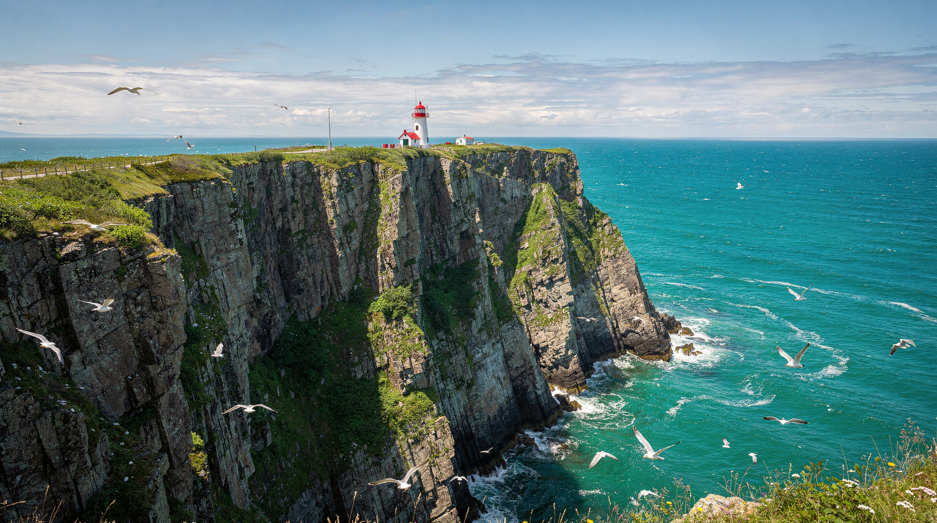
Cap-Gaspé trail (Les Graves)
The park’s signature hike runs 15 km round-trip from the Les Graves parking area to the lighthouse at Cap-Gaspé, the true tip of the peninsula. The trail follows the coastline at the base of the cliffs for the first half, then climbs to the lighthouse promontory for views of the Appalachian chain curving away into the Gulf.
Difficulty: moderate (15 km round-trip, 280 m elevation change). Allow 4-5 hours.
Wildlife: black bears are regularly seen along the lower section between Les Graves and the mid-point shelter. The park estimates 100-150 bears in the 244 km² area. Sightings are common in July-August, particularly in early morning. Parks Canada advises groups of 3+ and noise; bear spray is recommended and rentable at the park welcome centre.
Whales and seals: from the cliffs at mid-trail and the lighthouse point, minke whales and porpoises are frequently visible May-October. Grey seals haul out on rocks below the cliffs year-round. Binoculars are essential.
Mont Saint-Alban trail
The shorter but more aerobic option (6.4 km round-trip, 283 m elevation) to the observation tower at Mont Saint-Alban. The tower gives a 360° view: the Gulf to the north and east, the Chic-Chocs to the southwest, and on clear days, Anticosti Island. This is the best viewpoint in the park. Allow 2.5-3 hours.
Les Graves beach and historic fishing village
The En-Bas heritage site at Les Graves preserves the Hyman & Sons general store (circa 1920) and several fishing structures from the expropriated village. Summer interpreters in period costume explain the pre-park history. This adds authentic context to a park visit that might otherwise feel purely natural-history focused.
The shingle beach at Les Graves is swimmable in summer (water temperature 16-18°C in July, cold but manageable with conviction).
Sea kayaking
The park’s coastline is navigable by sea kayak from late May to October. Guided kayaking tours depart from the Les Graves or Cap-aux-Os areas; several operators in Gaspé town (40 km) offer guided half-day and full-day circuits with equipment. Independent paddlers must register with Parks Canada and follow the conditions of the sea kayak permit.
The passage around Cap-Bon-Ami (northern section of the park) involves exposed water and should only be attempted with experience or a guide.
Camping in Forillon
The park has three campgrounds:
Camping des Rosiers (north coast): the largest (200+ sites), close to the water, best for families. Sites 30-45 CAD depending on services. Opens mid-May.
Camping Cap-Bon-Ami (remote north): 44 sites, backcountry-feel, sea views. No electrical hookups. The most scenic campground. Opens mid-June.
Camping Penouille (south coast): 250+ sites, more sheltered from wind, near the Penouille beach. Open June-September.
Book ahead: all campgrounds fill for July-August weekends within hours of Parks Canada’s reservation window opening (early April). Book as early as possible at reservation.pc.gc.ca.
Park entry and logistics
Entry fee: approximately 10.50 CAD/adult, 21 CAD/family (2026 rate). Parks Canada Discovery Pass (150 CAD for up to 7 people in one vehicle, unlimited national park entries for 12 months) is good value for visitors planning to visit Forillon, La Gaspésie provincial park, and Parc de la Mauricie in the same trip.
Welcome centre (Cap-aux-Os): open daily June-October, 8h-17h. Trail maps, bear sightings board, bear spray rental (~10 CAD/day). Worth stopping before any hike.
Access: two main entrances. The Grand-Grève / Les Graves entrance (south side, Hwy 132 from Percé direction) serves the Cap-Gaspé trail. The Cap-aux-Os entrance (north side, from Gaspé town) serves the welcome centre, Cap-Bon-Ami, and Mont Saint-Alban.
Road condition: the main park roads are paved. The Cap-Bon-Ami access road is gravel (4 km, suitable for all cars in good weather; muddy after rain).
Wildlife calendar
| Month | What to expect |
|---|---|
| June | Bears active on trails, wildflowers, quieter crowds |
| July | Bears, whales, seals, peak bird activity, gannet colony at Percé |
| August | Bears, highest traffic, warm water |
| September | Foliage begins, bears foraging heavily, whale migration |
| October | Peak foliage (early), most services closing mid-month |
Where to stay near Forillon
Inside the park: see campgrounds above.
Gaspé town (40 km, 30 min): Hôtel des Commandants, Hôtel Gaspésie — both solid mid-range options, 120-180 CAD. Gaspé has grocery stores, fuel, and restaurants.
Cap-aux-Os: L’Auberge de la Rivière Dartmouth — small inn near the park’s north entrance, 110-150 CAD. Good base for the Mont Saint-Alban trail.
Percé (75 km): if combining Forillon with the rock and Île Bonaventure, basing in Percé and day-tripping to Forillon is practical — 1h drive each way, feasible for a full-day visit.
Getting there
From Gaspé town: 40 km east on Route 132 (30 minutes).
From Percé: 75 km west on Route 132 (1 hour).
There is no public transit to Forillon. A car is essential. Gaspé town has a rental car agency (National, seasonal).
Combining with other destinations
Forillon is best visited as part of the full Gaspé Peninsula loop, in combination with Percé and Gaspé town. Allow 2 days in the Percé-Forillon-Gaspé cluster — one day at Percé and Île Bonaventure, one day at Forillon.
For hikers who want more, the Chic-Chocs Mountains (Sainte-Anne-des-Monts, 3h west) offer a completely different highland experience — treeline, caribou, and elevation over 1 000 m. See the Gaspésie hiking guide and the complete Gaspé Peninsula road trip.