Best hikes in Québec: 12 trails worth the trip
Mont-Tremblant National Park Hiking Day
Duration: 8-10 hours
What are the best hikes in Québec?
The top hikes span the province: Mont-Albert (Gaspésie, expert, caribou), Cap-Trinité (Saguenay, hard, dramatic fjord views), Sentier des Caps (Charlevoix, multi-day), Mont-Tremblant Pic Johannsen (moderate), and Mont-Royal (Montréal, easy family). Season is May to October for most alpine trails; Forillon and Chic-Chocs open fully in June.
Québec hiking: a province built for trail runners and ridge walkers
Québec is not the first place most international visitors picture when they think of serious hiking. That is their loss. The province stretches over 1.5 million km² of Laurentian Shield, Appalachian foothills, coastal cliffs, and boreal plateau. Within that immensity sit some of the best-marked, best-managed trail systems in Canada — and among the least crowded relative to their quality.
The 12 trails in this guide were selected across the full geographic range of the province: Gaspésie in the east, Saguenay and Charlevoix along the north shore, the Laurentides interior, Montréal’s accessible urban park, and the Eastern Townships in the south. Difficulty ranges from a leisurely ridge walk suitable for older children to a demanding two-day traverse that should only be attempted by hikers in genuine backcountry shape.
All have real trailheads, confirmed access, and — where applicable — current entry fees. There are no fabricated details here.
The 12 best hikes in Québec
1. Mont-Albert — Gaspésie (expert)
Distance: 20 km loop | Elevation gain: 1 200 m | Duration: 8–10 hours | Access: ~9.85 CAD/adult (Parc national de la Gaspésie)
Mont-Albert sits at the heart of the Réserve de biosphère de la Gaspésie. The ascent climbs through boreal forest before breaking onto a wide, treeless plateau where woodland caribou — one of the only herds south of the Saint-Laurent — graze within sight of the trail. The summit views extend across the entire Chic-Chocs massif on clear days. Weather changes fast on the plateau: bring a shell and extra layers even in July.
The caribou herd of the Gaspésie (Rangifer tarandus caribou) numbers roughly 270 individuals as of 2026. The park has strict protocols for staying on trail and maintaining minimum observation distances of 100 m. Rangers take this seriously.
Best season: late June to early October. Snow can linger on the plateau into July.
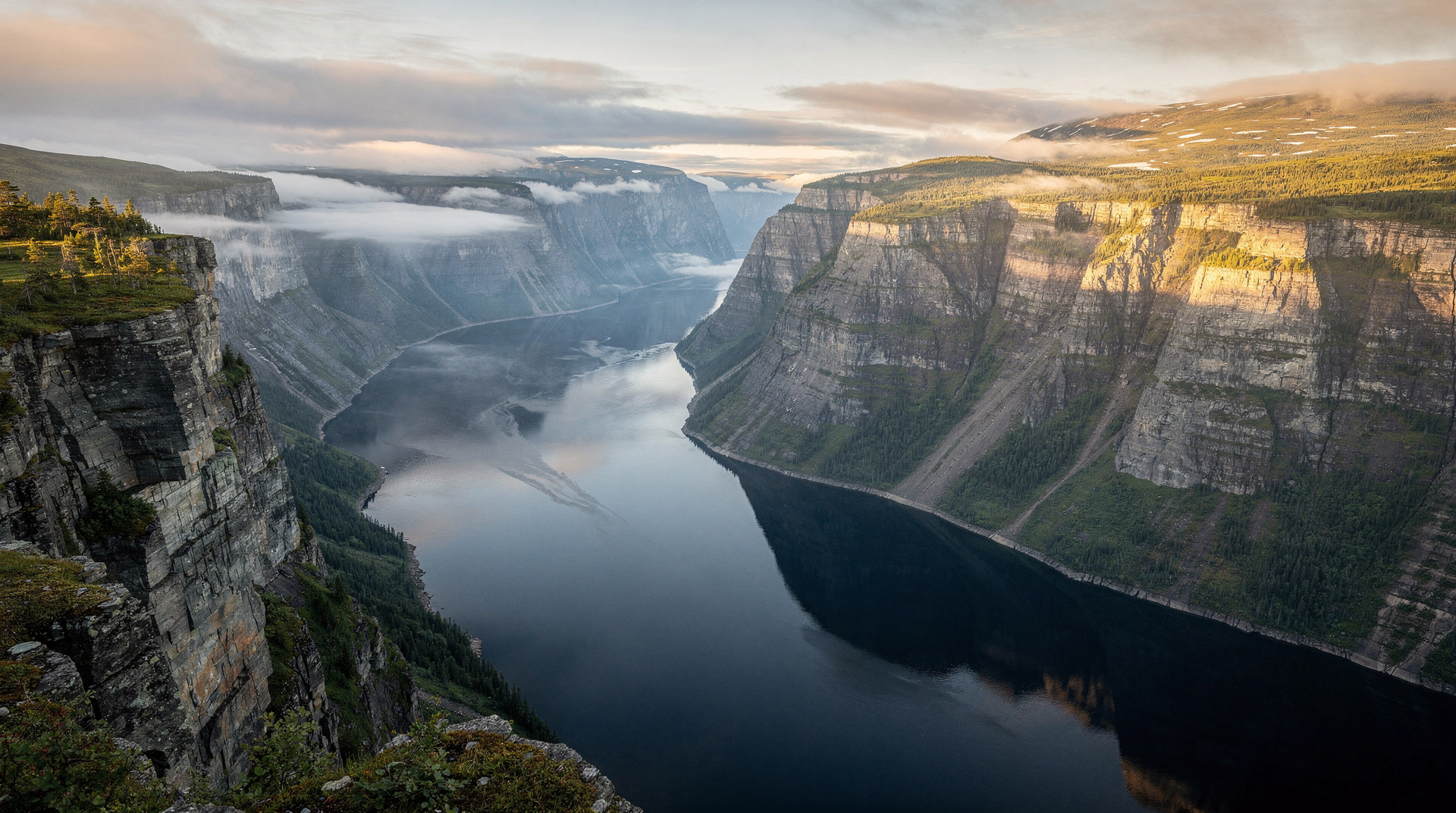
2. Cap-Trinité — Saguenay Fjord (hard)
Distance: 8.5 km one-way | Elevation gain: 450 m | Duration: 5–7 hours return | Access: Parc national du Fjord-du-Saguenay (9.85 CAD)
The trail climbs from the fjord floor to the famous cap where the 9-metre Notre-Dame statue has watched over the Saguenay since 1881. The reward is a 360° view from 518 m above sea level: sheer black cliffs dropping to steel-grey water 250 m below, beluga territory visible from the rock ledge. Exposure is significant on the final approach.
Saguenay Fjord classic cruise (La Baie, 3 hours) — for those who want to see Cap-Trinité from the water before or after the hike. The angle from the boat is as impressive as the view from the top, and gives you scale for how tall the cliffs truly are.
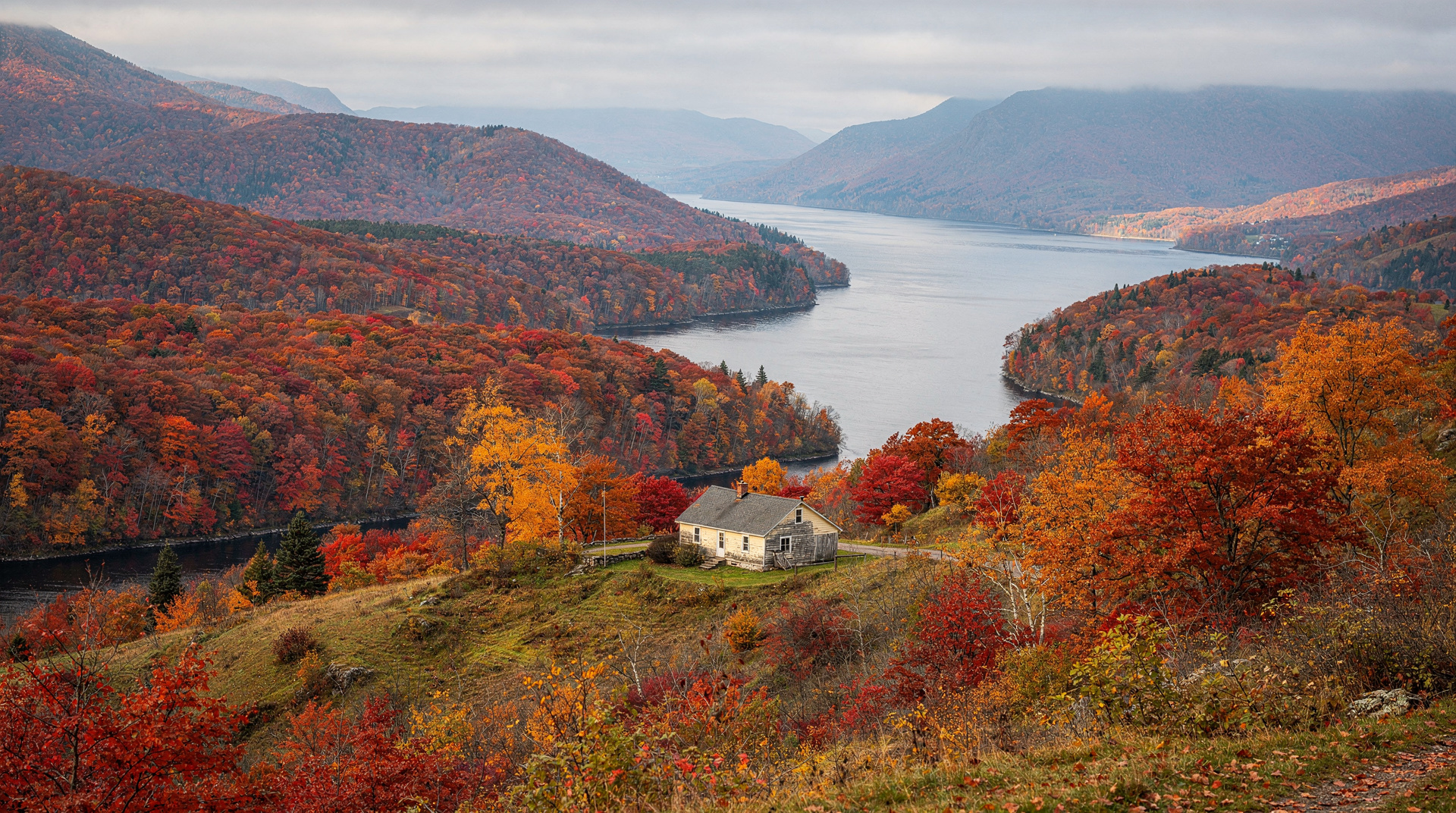
3. Sentier des Caps — Charlevoix (moderate to hard, multi-day)
Distance: 51 km total (sections from 13 km) | Duration: 2–3 days | Access fee: 25–40 CAD (includes refuge use)
The Sentier des Caps de Charlevoix traces the edge of the Charlevoix escarpment between Saint-Tite-des-Caps and Petite-Rivière-Saint-François, with views stretching over the Saint-Laurent toward the south shore. It is not a national park trail but a private non-profit operation with well-maintained refuges and lean-tos. Sections can be hiked as day trips from Québec City (roughly 60 km east).
The trail passes through old-growth sugar maple forest — stunning in late September during peak foliage.
4. Mont du Lac-des-Cygnes — Charlevoix (moderate)
Distance: 7.2 km | Elevation gain: 420 m | Duration: 3–4 hours | Access: Parc national des Grands-Jardins (9.85 CAD)
The summit at 980 m offers an open boreal landscape of krummholz spruce and lichen-covered rock typical of subarctic zones. On a clear day you can see the Saint-Laurent and, to the north, the rolling Laurentian plateau. A shorter loop option (3.5 km) makes the lower viewpoints accessible to families.
Grands-Jardins NP Via Ferrata Hike — for a more technical complement to the hiking day in the same park. The via ferrata adds iron rungs and cables on exposed rock faces, suitable for those with no rock-climbing experience but comfortable with heights.
5. Mont Saint-Hilaire — Montérégie (easy, family)
Distance: 5–12 km (multiple loops) | Elevation gain: 200–410 m | Duration: 2–4 hours | Access: 10 CAD/adult, 8 CAD/child
The closest challenging hike to Montréal (40 km, 40 minutes by car), Mont Saint-Hilaire is a UNESCO biosphere reserve managed by McGill University. The steep north face (Burnt Hill loop, 410 m gain) is genuinely demanding; the lower loops are appropriate for children aged 8 and up. Forest is primarily mature sugar maple and yellow birch — spectacular foliage mid-October.
No dogs allowed on trails — this is enforced. Park with limited spaces: arrive before 9h on weekends in September and October.
6. Sentier de la Vallée, Jacques-Cartier — Capitale-Nationale (easy to moderate)
Distance: 10 km | Elevation gain: 280 m | Duration: 3–4 hours | Access: Parc national de la Jacques-Cartier (9.85 CAD)
The valley floor trail follows the meandering Jacques-Cartier River through a 550 m deep glacial valley, with moose regularly spotted in the riverbed. The Sentier Les Crêtes variant adds a ridge section above the treeline with open views. Accessible year-round — this is also one of the best snowshoe trails in the Québec City region.
7. Mont-Royal — Montréal (easy, family)
Distance: 11 km (summit loop) | Elevation gain: 230 m | Duration: 2–3 hours | Access: Free (public park)
The obvious choice for Montréal and the most-walked trail in the province. The payoff is the Kondiaronk Belvedere at 233 m: a direct view over downtown Montréal and, on a clear day, toward the Adirondacks. The trail network under the Olmsted-designed park runs 11 km; the main summit circuit takes 2 hours at a comfortable pace. The cross at the summit is lit at night and visible across the city.
Mont-Tremblant National Park hiking day trip from Montréal — the logical upgrade from Mont-Royal if you have a full day and no car. This guided day trip covers the park’s main trails and handles transport from the city.
8. Pic Johannsen — Parc national du Mont-Tremblant (moderate)
Distance: 14 km return | Elevation gain: 480 m | Duration: 5–6 hours | Access: Parc national du Mont-Tremblant, 9.85 CAD
The highest accessible trail in Parc national du Mont-Tremblant (distinct from the ski resort). The summit at 960 m offers unobstructed views over the Laurentian lakes. Best in early October for foliage. Trail is well-marked and wide for the first 8 km, narrower and more technical above the treeline.
9. Mont-Saint-Alban — Forillon, Gaspésie (moderate)
Distance: 7.5 km return | Elevation gain: 272 m | Duration: 3–4 hours | Access: Parc national Forillon (Parks Canada, ~10.20 CAD/adult)
The shortest route to the best viewpoint in Forillon: the firetower summit at 272 m gives you a 360° panorama of the Gaspé Peninsula, the Gulf of Saint-Laurent, and — on a clear morning — the outline of the Percé Rock 60 km away. Black bears are regularly spotted on this trail. The seasonal Parks Canada campground at Cap-Bon-Ami is 10 minutes by car from the trailhead.
Forillon’s season runs June to October (full services). Some trails remain passable in May and November.
10. Sentier Statue de la Vierge — Saguenay Fjord (easy)
Distance: 1.5 km one-way | Elevation gain: 200 m | Duration: 1.5 hours return | Access: Parc national du Fjord-du-Saguenay
The short but steep trail to the Notre-Dame statue at Cap-Trinité is accessible as a standalone walk without committing to the full 8.5 km. It is the most popular trail in the fjord park and the one that fills the parking lot on weekends in July and August. If you are not hiking the full cap, the statue trail still gives you a credible fjord view from an unusual perspective.
11. Lac aux Américains — Chic-Chocs, Gaspésie (moderate)
Distance: 8 km return | Elevation gain: 380 m | Duration: 3.5–4.5 hours | Access: Réserve faunique des Chic-Chocs (booking required)
The Lac aux Américains is a glacial cirque lake sitting at 800 m in the Chic-Chocs massif. The approach passes through dense spruce-fir forest before opening onto a talus slope with views of the surrounding peaks. Caribou from the Mont-Albert herd occasionally come through this corridor in early summer. Backcountry camping at the lakeside shelter must be reserved in advance through Sépaq.
12. Mont-Orford — Cantons-de-l’Est (moderate)
Distance: 11 km (summit loop) | Elevation gain: 580 m | Duration: 4–5 hours | Access: Parc national du Mont-Orford (9.85 CAD)
The highest point in the Eastern Townships at 853 m, Mont-Orford is a reliable autumn hike: sugar maple and yellow birch give the forest extraordinary colour in early to mid-October. The summit is open rock with views southwest toward Vermont and New Hampshire. Accessible from Montréal in 1 hour 30 minutes and from Sherbrooke in 30 minutes.
How to plan a Québec hiking trip
The Sépaq annual pass
If you are visiting three or more Sépaq parks (Jacques-Cartier, Tremblant, Gaspésie, Forillon excluded — that is Parks Canada), the unlimited-access annual pass costs around 72 CAD per adult and pays off quickly. Available online or at park entrances.
Forillon and Parks Canada
Forillon is managed by Parks Canada, not Sépaq. Entry fees are slightly different and the Discovery Pass (annual Parks Canada pass, ~75 CAD) covers all federal parks across the country. Useful if you are also visiting Mingan Archipelago or Fundy.
Car logistics
You need a car for all 12 trails on this list except Mont-Royal. The Parc national de la Jacques-Cartier is 40 minutes from Québec City; Forillon is 700 km from Montréal (fly to Gaspé, YGP, if you have limited time). Plan distances realistically: Montréal to Gaspésie is roughly 10–12 hours of driving.
For hikes combining the Laurentides and Québec City region, base yourself in Québec City and rent a car — Jacques-Cartier and Charlevoix are each under 2 hours.
Combining hiking and whale watching
The Saguenay trails (Cap-Trinité, Sentier Statue) pair naturally with the whale-watching season in Tadoussac (May to October). You can do a morning hike and an afternoon boat tour on the same day.
Whales and Fjord morning or twilight tour (Tadoussac) — the early-morning departure gives the best light for photography and the highest chances of fin whale sightings in July and August.
What to bring on Québec hikes
Even in summer, Québec mountain weather changes rapidly — this is not the Alps, but a 10°C temperature drop and sudden fog are common on any of the Gaspésie or Charlevoix plateaux. Standard checklist:
- Trekking poles (compulsory on trails with significant root/mud sections, which is most of them after rain)
- Rain shell plus insulating mid-layer, even in July
- Bear spray (available at park entrances and outdoor retailers)
- 2–3 litres of water; most park trails have no reliable water sources after the first few kilometres
- Head lamp with spare batteries (critical if you underestimate time on long trails)
- Printed or downloaded offline map — signal is absent in all the backcountry areas on this list
Good boots matter. Trail runners work on the lower-elevation, well-maintained trails (Mont-Royal, Lac aux Américains). Stiff-soled hiking boots with ankle support are strongly recommended for Mont-Albert, Cap-Trinité, and Sentier des Caps.
Related guides
- Hiking Jacques-Cartier National Park
- Hiking Forillon National Park
- Hiking Mont-Tremblant National Park
- Hiking the Saguenay Fjord
- Gaspésie and Chic-Chocs trekking
- Best time to visit Québec
Frequently asked questions about Best hikes in Québec: 12 trails worth the trip
Do I need permits to hike in Québec national parks?
Most Sépaq-managed national parks charge a daily access fee (around 9.85 CAD per adult in 2026). Forillon (Parks Canada) has separate fees. Backcountry campsites and shelters require advance booking, especially in the Chic-Chocs where spaces fill weeks ahead.When do Québec hiking trails open?
Lower-elevation trails open April to May. Alpine areas (Mont-Albert, Chic-Chocs) and coastal parks (Forillon) are best from mid-June. Leaf-peeping hikes in the Laurentides and Charlevoix peak late September. Many trails remain accessible for snowshoeing November to March.Is it safe to hike alone in Québec wilderness?
Solo hiking is common but demands preparation: file your itinerary with the park office, carry a satellite communicator in remote areas (Chic-Chocs, Saguenay backcountry), bring bear spray (black bears are present in most parks), and check weather forecasts. Cell coverage is absent in most wild areas.What wildlife can I expect on Québec hikes?
Black bears are present province-wide (mostly shy). Moose are common in Jacques-Cartier, Mauricie, and Gaspésie parks. Woodland caribou survive in the Chic-Chocs (around 270 individuals) and require strict observation protocols. Seals and the occasional whale are visible near Forillon and Saguenay coastal trails.What is the most difficult hike in Québec?
Mont-Albert in the Gaspésie is widely considered the most demanding single-day hike: 20 km, 1 200 m elevation gain, exposed plateau in changeable weather. The Sentier du Fjord (35 km, Saguenay) is harder in terms of cumulative effort over multiple days. Both require full backcountry fitness.
Top experiences
Bookable activities with verified prices and instant confirmation on GetYourGuide.